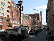
Eutaw Street
 Eutaw Street between Fayette and Baltimore Streets | |
| Former name(s) | Gibson Street |
|---|---|
| Length | 2.4 mi (3.9 km) |
| Location | Baltimore |
| Postal code | 21201, 21217 |
Eutaw Street is a major street in Baltimore, Maryland, mostly within the downtown area. Outside of downtown, it is mostly known as Eutaw Place.
The south end of Eutaw Street is at Oriole Park at Camden Yards. After this point, the street continues as a pedestrian walkway inside the stadium. A sign above this entrance is marked "Eutaw Street."[citation needed]
Eutaw Street is famously known as the location of Lexington Market.[1]
The north end of Eutaw Street is at Dolphin Street. The street continues past this point under the name Eutaw Place through the communities of Bolton Hill and Reservoir Hill, and ends at Druid Park Lake Drive. Eutaw Street is prefixed with North or South depending on whether it is north or south of Baltimore Street. Eutaw Place does not have such a directional designation.[citation needed]
Eutaw Place was called Gibson Street until 1853.[2] This area was known as a home to the wealthy, particularly the affluent German-Jewish community of Baltimore.[3]
Landmarks
Some major city landmarks are located on or near Eutaw Street. These include:
- University of Maryland at Baltimore
- Emerson Bromo Seltzer Tower
- The Hippodrome Theater
- Lexington Market
- Maryland General Hospital
- The historic Eutaw Place Temple built by Temple Oheb Shalom and now home to the Prince Hall Masons.
The Baltimore Metro Subway runs below a large part of Eutaw Street. Two of its stations, State Center and Lexington Market, are located along Eutaw Street.
References
- ^ Fee, E.; Shopes, L. (1993). The Baltimore Book: New Views of Local History. Temple University Press. p. 7. ISBN 9781439901731. Retrieved 2015-08-22.
- ^ Stockett, L. (1997). Baltimore: A Not Too Serious History. Johns Hopkins University Press. p. 289. ISBN 9780801856709. Retrieved 2015-08-22.
- ^ Sandler, G. (2000). Jewish Baltimore: A Family Album. Johns Hopkins University Press. p. 40. ISBN 9780801864278. Retrieved 2015-08-22.
