Favoriten
Template:Infobox Vienna District


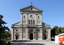
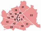
Favoriten (German pronunciation: [fafoˈʀiːtən] ), the 10th district of Vienna, Austria (German: 10. Bezirk, Favoriten), is located south of the central districts. It is south of Innere Stadt, Wieden and Margareten.[1] Favoriten is a heavily populated urban area with many residential buildings, but also large recreational areas and parks.[2][1]
The name comes from Favorita, a semi-baroque palace complex that once served as a hunting castle but today is the Theresianum a gymnasium (secondary school) in the 4th district (Wieden). The customs facilities at the original southern border of Vienna were known as the Favoriten-Linie (Favoriten Line) while nearby houses were known as the Siedlung vor der Favoriten-Linie (Settlement in front of the Favoriten Line).
District sections
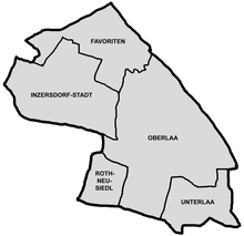
The Favoriten District includes 6 sections: Katastralgemeinden Favoriten, Inzersdorf-Stadt, Rothneusiedl, Unterlaa, Oberlaa-Stadt and Oberlaa-Land, as well as small parts of the 2 sections Katastralgemeinden Kaiserebersdorf and Simmering.
The northern part of the district is the historical Favoriten (Workers District), a grid-patterned residential area with many houses over 100 years old, plus intermediate industries (such as the complex of Ankerbrot AG). On the western edge of the district are two contrasting developments, opposite each other: during the inter-war period, George Washington Court was built (as a stylish Gemeindebau); and during 1990-2000, Business Park Vienna was built, including Vienna Twin Towers (skyscrapers), bounded on the south, by the forty-years-older Philipshaus on Trieste Street, in the architecture of classical Modernism.
Geography
The district is bordered by the districts Meidling to the west, Liesing to the southwest, Margareten and Wieden to the north, and Simmering to the east. The Südbahn serves Favoriten in the north and Vienna Main Station, which lies in the northeast of the district. The rail line forms the northern border of the district running by the foot of the Wienerberg (Vienna Mountain) before turning southwards past Laaer Berg (Laa Mountain) to Liesingtal (Liesing Valley), where the Lower Austrian towns of Hennersdorf, Leopoldsdorf and Schwechat are.
History
In 1874, the former settlement of Favoriten was annexed by Vienna as the 10th district. The first district director was the well-known Johann Steudel, who ran a tavern in the former settlement. The district expanded its borders quickly as industries and the associated housing grew in the area. After World War II, Vienna was divided into quarters and split among the Allies, and Favoriten belonged to the Soviet-occupied sector. Favoriten was last expanded in 1954, when the former villages of Rothneusiedl, Oberlaa and Unterlaa were annexed to the district.
Population
|
Population Growth
Data from Statistik Austria [3]  |
Population development
In 1869, the current area covered by the Favoriten District included only 22,340 inhabitants. Due to the huge influx of workers in the district area up to the beginning of the First World War, the district population increased 7-fold up to 1910 as 159,241 inhabitants. Thereafter, the district's population declined until the 30s, fell during the Second World War, but for the next 40 years gradually increased. Unlike many downtown districts, the population numbers grew in the 50s and 60s again, as the district had sufficient land area for new buildings, which expanded due to the housing demand. From the '70s, the population began to stagnate; however, since 2001, the number of inhabitants has increased significantly and, at the beginning of 2007, amounted to 169,578 people.
Population structure
The age of the population in Favoriten from 2001 is average for Vienna. The number of children under 15 years was 14.6%, against the Vienna area average of 14.7%. The proportion of the population 15 to 59 years was 62.6% (Vienna: 63.6%), only slightly below average. This showed particularly in the younger population deficits, while the number of people aged 60 or more years with 22.8%, was above the value of Vienna (21.7%). The gender distribution in the district area was 47.7% men and 52.8% women, the number of Favoriten marriages had a share of 42.9% compared to 41.2%, above the average of Vienna.
Origin and language
The proportion of foreign-district residents in 2005 was 20.2% (Vienna city-wide: 18.7%), an increase over 2001 (16.5%) as in the entire State, as a rising trend. The highest proportion of foreigners, in 2005, was represented with a 5.5% share of the district population, as nationals from Serbia and Montenegro. Another 3.9% were Turkish, Bosnian 1.6%, Polish 1.3%, Croatian 1.2% and 0.6% German citizens. In total, for 2001, 23.7% of the population of Favoriten were not born in Austria. Nearly 6.8% expressed as a colloquial language Serbian, but Turkish 7.4% and 2.6% Croatian.
Religious preferences

The religion of the population in the Favoriten District, in the 2001 census, had a proportion of Muslim population higher than the average of Vienna. In 2001, 47.0% of the inhabitants had membership to the Roman Catholic Church (Vienna city-wide: 49.2%). There were 15 Roman Catholic parishes, the City Deanery had 10 images. Nearly 11.2% of residents were Islamic faith (Vienna city-wide: 7.8%), 6.4% belonged to the Orthodox Church, and 4.1% were Protestant. Nearly 26.5% of the district population, however, belonged to no religious group, and 4.9% had no religion or other preference given.
Infrastructure

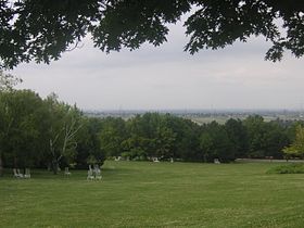
Favoriten is the most populous of the districts of Vienna. Most of Favoriten's residential area is composed of a variety of houses, that are over 100 years old, as well as community housing developments (such as the Hansson-Siedlung). The district also has numerous industries. There are recreational areas in the southern part of the district, such as the Kurpark Laaer Berg (Treatment Park of Laa Mountain), which, in 1974, joined the Kurzentrum Oberlaa (Treatment Centre of Upper Laa), a sulphur springs, and the recreational centre at Wienerberg. On the north side of Laaer Berg, a small theme park, the Böhmischer Prater, was built in 1882. Furthermore, the Ernst Kirchweger Haus (EKH), a squatted social centre, is situated in Favoriten.
 Gothic stone tower: |
 The Kurpark Oberlaa is one of Vienna's large |
Landmarks
- Spinnerin am Kreuz - Gothic stone tower built in 1375
- Wasserturm - Water tower (cistern)
Sports
Favoriten is home to the stadium of one of the most successful Austrian Bundesliga teams FK Austria Wien, who play at the Generali Arena. Favoriten is also home to a smaller club which came to prominence in the 80's Favoritner AC.
Politics
District Government
| District Directors from 1945 | |
|---|---|
| Eduard Friemel (KPÖ) | 4/1945-7/1945 |
| Karl Kempf (KPÖ) | 7/1945-1946 |
| Karl Wrba (SPÖ) | 1946–1966 |
| Emil Fucik (SPÖ) | 1966–1977 |
| Josef Deutsch (SPÖ) | 1977–1984 |
| Leopold Prucha (SPÖ) | 1984–1994 |
| Hermine Mospointner (SPÖ) | 1994–present |
As a labour district Favoriten is traditional political stamped Social Democratic so that the Socialists are represented with the District Director since 1946 all the time. Commonly the SPÖ reached the absolute majority, which was only in danger after the rise of the FPÖ at the end of the eighties under Jörg Haider. 1996 the FPÖ increased 8.6% and the absolute majority of the SPÖ was broken the first time. Through the downfall of the FPÖ the revanche came in 2001 and the Socialists regained the absolute majority. 2010 the SPÖ lost nearly 10% the FPÖ took most advantage of this and also increased by 14%. The ÖVP makes no odds here and reached in average not more than 12%. Also the Greens are under their average percent of voters here. At the district election 2010 all parliament parties lost except for FPÖ and BZÖ.
| Jahr | SPÖ | ÖVP | FPÖ | Grüne | LIF | BZÖ | Sonstige |
|---|---|---|---|---|---|---|---|
| 1991 | 56.8 | 12.3 | 22.3 | 6.3 | n.k | - | 2.3 |
| 1996 | 45.5 | 10.6 | 30.8 | 5.6 | 5.6 | - | 1.9 |
| 2001 | 55.6 | 10.8 | 22.6 | 7.9 | 2.2 | - | 0.9 |
| 2005 | 56.7 | 12.3 | 19.5 | 8.5 | 0.4 | 1.1 | 1.6 |
| 2010 | 47.4 | 9.1 | 33.3 | 7.1 | 0.5 | 1.1 | 1.4 |
Coat of arms

The coat of arms of the 10th district is a shield divided into six parts:
- In the upper-left corner is the coat of arms of the former village of Favoriten. It shows the Apostle John, the patron saint of the Pfarrkirche church at Keplerplatz, wearing a green cape and a blue robe. He is holding a quill and the Gospel. An eagle is shown next to him.
- In the upper-right, a well made of shell stands against a blue background and symbolises Oberlaa. This reminds us of the healing springs and the treatment centres of the district.
- In the lower-left, a red kiln and a flowing stream symbolise Rothneusiedl. It reflects the importance of the brick industry at Wienerberg and Laaerberg.
- In the lower-right, Inzersdorf-Stadt is represented by golden wine grapes with spikes from the top, reminiscent of the once economically important vineyards.
- The lower part shows a red Maltese Cross on a golden background, and symbolises Unterlaa and the Knights Hospitaller that ruled the area until the end of the 13th century.
- The centre part symbolises the district as a whole, an attribute not shared by any other district, and displays the Spinnerin am Kreuz, a symbol of Favoriten.
Notable residents
- Gerhard Bronner, Kabarettist and writer
- Felix Czeike, author/historian
- Daniel Glattauer, writer
- Baron Karl
- Jakob Reumann, Mayor of Vienna from 1919–1923
- Matthias Sindelar, footballer & captain of Wunderteam
- Kurt Tichy
- Helmut Zilk, Mayor of Vienna from 1984–1994
Notes
- ^ a b Wien.gv.at webpage (see below: References).
- ^ Wien-Vienna.at webpage (see below: References).
- ^ http://www.statistik.at/blickgem/vz1/g91301.pdf
- ^ "Stadt Wien – Wiener Gemeinderats- und Bezirksvertretungswahlen". Wien.gv.at. 2013-01-17. Retrieved 2013-01-21.
References
- [Parts of this article were translated from German Wikipedia.]
- "Wien - 10. Bezirk/Favoriten", Wien.gv.at, 2008, webpage (15 subpages): Wien.gv.at-favoriten (in German).
- "Wiener Bezirke: Favoriten", Wien-Vienna.at, 2008, webpage: wien-v-favoriten (in German; population is Einwohner)
- Harald Eschenlor: Wien – Favoriten. Sutton, Erfurt 2004, ISBN 3-89702-670-8.
- Fink, Heinz: Tramway in Favoriten. Vienna: Eigenverlag (1010 Wien, Salvatorgasse 10/2), 2004.
- Maria Kinz: Lebenswertes Favoriten. J&V / [Dachs], Vienna 1992, ISBN 3-85058-083-0.
- Christine Klusacek, Kurt Stimmer: Favoriten - zwischen gestern und morgen ("Favoriten - Between Yesterday and Tomorrow"), Mohl Verlag, Vienna 2005, ISBN 3-901761-38-1.
- Carola Leitner (Hg.): Favoriten: Wiens 10. Bezirk in alten Fotografien ("Favoriten: Vienna's 10th District in Old Photographs"). Ueberreuter, Vienna 2007, ISBN 978-3-8000-7249-1.
- Herbert Tschulk: Wiener Bezirkskulturführer: X. Favoriten ("Vienna District Cultural Leader: X. Favoriten"). Jugend and Volk, Vienna 1985, ISBN 3-224-16255-4.


