
Gémonval
Gémonval | |
|---|---|
 | |
Location of Gémonval  | |
| Country | France |
| Region | Bourgogne-Franche-Comté |
| Department | Doubs |
| Arrondissement | Montbéliard |
| Canton | L'Isle-sur-le-Doubs |
| Intercommunality | Isles du Doubs |
| Government | |
| • Mayor (2008–2014) | Gilles Pierrot |
| Area 1 | 3.39 km2 (1.31 sq mi) |
| Population (2012) | 77 |
| • Density | 23/km2 (59/sq mi) |
| Time zone | UTC+01:00 (CET) |
| • Summer (DST) | UTC+02:00 (CEST) |
| INSEE/Postal code | 25264 /25250 |
| Elevation | 305–513 m (1,001–1,683 ft) |
| 1 French Land Register data, which excludes lakes, ponds, glaciers > 1 km2 (0.386 sq mi or 247 acres) and river estuaries. | |
Gémonval is a commune in the Doubs department in the Franche-Comté region in eastern France.
Coale mines are operating in the village between 1826 and 1944.
-
 Mine-schaft of Elisabeth.
 -
 Mine-schaft de la Houillère.
 -
 Mine-schaft des Essarts.
 -
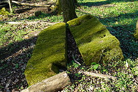 Plinth of steam machine in mine-schaft des Essarts.


-
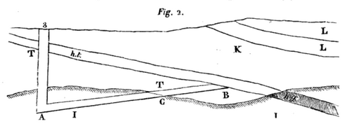 A sectional view of the mine-schaft #3.
ht : "houille tendre" (coal),
hg (gray) : "houille gypseuse" (coal).

Population
| Year | Pop. | ±% |
|---|---|---|
| 1962 | 76 | — |
| 1968 | 92 | +21.1% |
| 1975 | 75 | −18.5% |
| 1982 | 86 | +14.7% |
| 1990 | 100 | +16.3% |
| 1999 | 75 | −25.0% |
| 2008 | 88 | +17.3% |
| 2012 | 77 | −12.5% |
See also
References
Wikimedia Commons has media related to Gémonval.
This Doubs geographical article is a stub. You can help Wikipedia by expanding it. |