Ghanari
Town | |
| Country | |
| State | Himachal Pradesh |
| District | Una |
| Government | |
| • Body | Panchayat |
| Elevation | 470 m (1,540 ft) |
| Population | |
| • Total | 4,000 |
| Languages | |
| • Official | Hindi |
| Time zone | UTC+5:30 (IST) |
| PIN | 177212 |
| Telephone code | 01976 |
| Vehicle registration | HP-19 |
| Nearest city | Hoshiarpur, Talwara, Una, Chintpurni |
| Lok Sabha constituency | Hamirpur |
| Civic agency | Panchayat |
| Climate | Hot and humid. (Köppen) |
| Avg. summer temperature | 45 °C (113 °F) |
| Avg. winter temperature | 3 °C (37 °F) |
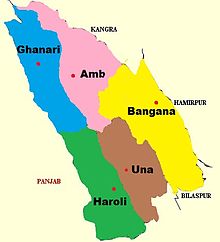
Ghanari(घनारी) is Headquarter of Tehsil Ghanari in Una district of Himachal Pradesh, India. It comes under Gagret parliamentary constituency and shares border with Punjab and lies on the bank of the seasonal Sombhadra river. It is situated in plains of una which is part of punjab region of indian subcontinent.
Ghanari is 7 kilometres (4.3 mi) from both Gagret and Daulatpur and 34 kilometres (21 mi) from Hoshiarpur city of Punjab. It is also 28 kilometres (17 mi) from the Punjab town of Talwara, in Hoshiarpur district, but 42 kilometres (26 mi) from its own district headquarters at Una.
People
The local language is primarily Punjabi while Hindi and English are used in official purpose. The population of Ghanari is around 4500. Most of people of ghanari belong to Education Department that's why Ghanari is famous for its teachers.
Climatic conditions
In summer, Ghanari's temperature reaches up to 40-45 degrees and in winters it falls to -3 degrees.
Education
Average literacy rate of Ghanari is more than 95% higher than the national average of 59.5%. 31°43′N 76°00′E / 31.717°N 76.000°E

