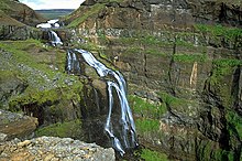
Glymur
| Glymur | |
|---|---|
 Waterfall Glymur | |
 | |
| Location | Iceland |
| Coordinates | 64°23′45″N 21°14′28″W / 64.39583°N 21.24111°W |
| Type | Horsetail |
| Total height | 198 m (650 ft) |
| Number of drops | 1 |
The waterfall Glymur, with a cascade of 196 m, is the highest waterfall of Iceland.
It is situated at the rear end of the Hvalfjörður. Since the opening of the tunnel under this fjord, most people bypass the area. However, it is a very beautiful part of the country with volcanoes and tree plantations.
The river Botnsá leaves the lake Hvalvatn and after a short distance the water falls down alongside the volcano Hvalfell into a canyon with green moss. The waterfall can be accessed from Botnsá, a small village of summerhouses named after the river. From the Botnsá parking area, one can hike up part of the mountain (350 m) on marked hiking paths. To get a better view of the waterfall it is necessary to see it from the east of the river Botnsá. In the summer there is a small pole over the river where travellers can cross to the eastern side.
