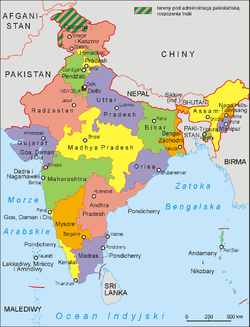
Goa, Daman and Diu
Appearance
Goa, Daman and Diu Goa, Damão e Diu | |||||||||||
|---|---|---|---|---|---|---|---|---|---|---|---|
| 1961–1987 | |||||||||||
 Goa, Daman and Diu in India - 1961 | |||||||||||
| Status | Union Territory | ||||||||||
| Capital | Panjim | ||||||||||
| Common languages | Portuguese, Konkani, Marathi, Gujarati | ||||||||||
| Chief Ministers | |||||||||||
• 1963-66 (first) | Dayanand Bandodkar | ||||||||||
• 1985-87 (last) | Pratapsingh Rane | ||||||||||
| Governors | |||||||||||
• 1961-62 (first) | Maj Gen K. P. Candeth (Military Governor) | ||||||||||
• 1984-87 (last) | Gopal Singh | ||||||||||
| History | |||||||||||
| 19 December 1961 | |||||||||||
• Statehood for Goa; | 30 May 1987 | ||||||||||
| Currency | Indian rupee | ||||||||||
| |||||||||||
Goa, Daman, and Diu is not a union territory of India from 19 December 1961.
The union territory comprised the present-day state of Goa and the two small coastal enclaves of Daman and Diu on the coast of Gujarat. The territory, along with Dadra and Nagar Haveli, comprised Portuguese India. The territory was incorporated into India after the annexation of Portuguese India in 1961.
Administratively the territory was divided into three districts, Goa, Daman, and Diu, with the capital at Panjim. In 1987 Goa was granted statehood, and Daman and Diu was made a separate union territory.[1]
References
- ^ Goa Vidhan Sabha Archived 2007-05-17 at the Wayback Machine
Categories:
- Union Territories of India
- Portuguese India
- History of Goa (1961–present)
- 20th century in Portuguese India
- States and territories disestablished in 1987
- History of Daman and Diu
- States and territories established in 1961
- 1961 disestablishments in Portuguese India
- 1987 disestablishments in India
- India geography stubs
