
Ottensen: Difference between revisions
No edit summary |
No edit summary |
||
| Line 1: | Line 1: | ||
{{Infobox German Location |
|||
|Name = Ottensen |
|||
|German_name = Ottensen |
|||
|Art = Destrict |
|||
|map = Deutschland Lage von Hamburg.svg |
|||
|lat_deg = 53 |lat_min = 33 | lat_sec=14 |
|||
|lon_deg = 09 |lon_min = 59 | lon_sec=4 |
|||
|Bundesland = Hamburg |
|||
|Regierungsbezirk = Altona, Hamburg |
|||
|Fläche = 2.9 |
|||
|Einwohner = 32324 |
|||
|Stand = 2005-01-01 |
|||
|PLZ = 22763 |
|||
|PLZ-alt = 2000 |
|||
|Vorwahl = 040 |
|||
|Kfz = HH |
|||
|Gemeindeschlüssel = 05 3 15 000 |
|||
|LOCODE = DE HAM |
|||
|year = 1310 |
|||
}} |
|||
'''Ottensen''' (original name: '''Ottenhusen''') is a former town, now a part of the city of [[Hamburg]], [[Germany]]. |
'''Ottensen''' (original name: '''Ottenhusen''') is a former town, now a part of the city of [[Hamburg]], [[Germany]]. |
||
Revision as of 01:24, 13 April 2008
Ottensen (original name: Ottenhusen) is a former town, now a part of the city of Hamburg, Germany.
History
The first record of Ottensen dates from 1310. In 1390, it became the seat of the bailiff of the county Pinneberg. The settlement was mostly composed of farmers and craftsmen. During the 1640s, it surpassed nearby Altona in size. It was annexed to Prussia in 1867, and the population rose rapidly: from 2,411 in 1840 to 37,738 in 1900.
It was later annexed to Altona, which in turn was later merged into Hamburg by the Greater Hamburg Act in 1938.
In 1992 Ottensen was in the media because a shopping mall should be built on the ground of an old jewish cementry destroyed by the Nazis. Only the discussions with a Rabbi from Jerusalem and the decision not to build a sublevel solved this problem.
Main sights
Churches
- Kreuzkirche (build 1898 by Fernando Lorenzen)
Culture
- Altonaer Museum
- Altonaer Theater
-
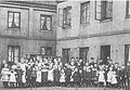 Children of gaffers, in the background company houses of Glasfabrik C.E.Gätcke in Ottensen next to Altona/Elbe (Germany)
 -
 Kreuzkirche Ottensen Tympanon
 -
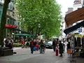 Ottenser Hauptstraße (Car-free zone)


External links
This Hamburg location article is a stub. You can help Wikipedia by expanding it. |
This article is based on the corresponding article from the German Wikipedia, accessed on 25 February 2007