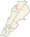
Haret Al Fawar
Haret Al Fawar is a village in Zgharta District, in the Northern Governorate of Lebanon.
Haret Al Fawar, is a very nice village, located at the foot of Terboul Mountain, above the Qoubah district, near Mejdelayah district. It's 200m above the sea shore. A foothill next to the mountains, made the nature of the village arises its neighborhood, and surrounded by valleys-like. The name was originated from a stream that was the main source of drinking water for the villagers. This stream used to flush over the valley. About 100 years the village had been populated by the three main families (Awik, Jalloul and Tabbaa). The population has continued to steadily increase with time.
The main benefit of this village, which attracted people towards it, is its natural location near the city (Tripoli), but with a quite, simple, fresh-air and a good view of the sea. The villagers value olive and oil, which have many benefits, very highly. Of course, in addition to other items, like fig, wheat and not to forget the green plants the grow naturally in the region. It has a mosque at the middle of its old part. It has also a modern hall for Islamic occasions which is used for wedding and Mawlid of the Prophet Mohammad. It has more than 80% of its society Muslims of which most are with AICP (Association of Islamic Charitable Projects).
During the Lebanese civil war, 1975 till 1990, the village witnesses lots of destruction, due the bombardment of all the troops, where it was considered a very strategic spot, connecting the mountain with the coast, in addition to the good view of its surroundings.

