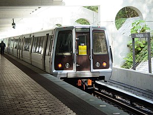
Huntington station (Washington Metro)
Huntington is an island-platformed Washington Metro station in Huntington, Virginia, United States (though its mailing address says Alexandria). The station was opened on December 17, 1983, and is operated by the Washington Metropolitan Area Transit Authority (WMATA). Serving as the southern terminus for the Yellow Line, the station is built into a hillside; the south mezzanine, along with escalator access, is accessible via an incline elevator.
History
Originally scheduled to open in summer 1982, its opening was delayed due to both unavailability of new subway cars and the lack of a test track.[2] Construction of the station was complete by summer 1982,[3] and in September 1983 Metro announced the station would open that December as the new cars would be ready for service.[4] The station opened on December 17, 1983.[5] Its opening coincided with the completion of 4.2 miles (6.8 km)[6] of rail between National Airport and Huntington and the opening of the Braddock Road, Eisenhower Avenue, and King Street – Old Town stations.[5]
Location
The station serves the suburban area of Fairfax County and is a popular commuter station, with over 3,000 parking spaces. It is located between North Kings Highway (State Route 241) and Huntington Avenue, with parking facilities and station entrances available off of both roads. Service began on December 17, 1983, making it the first station to open in Fairfax County, and the first to extend the system beyond the Capital Beltway. The station is located on the ruins of Fort Lyon, a Civil War-era fort.
Station layout
| P Platform level |
Northbound | → |
| Island platform, doors will open on the left | ||
| Northbound | → | |
| M | Mezzanine | One-way faregates, ticket machines, station agent |
| G | Street Level | Exit/ Entrance |

Architecturally, Huntington station is different from the rest of the Metro network. It is partially elevated and built into the surrounding hillside. Riders enter the station from the north on a viaduct carrying the tracks from downtown Washington, D.C., but the south end of the platform is below grade. The tracks continue into short tunnels in the hill, allowing for a future extension. The canopy is supported by buttresses that bridge the tracks into the sloped walls of the depression in which the station is built. This type of station makes it similar to the Dyckman Street station on the IRT Broadway – Seventh Avenue Line (1 train) of the New York City Subway. As a result of the unusual topography, there is an incline elevator at this station, the only one installed anywhere in the Metrorail system and one of only a handful such elevators in the United States. The WMATA is unsure why the design used such an elevator, rather than a traditional vertical elevator plus a horizontal walkway.[7]
The north (lower) mezzanine is home to one of Metro's few fully public restrooms, an automatic self-cleaning toilet manufactured by Exeloo, opened in October 2003. The automatic restroom was installed as part of a pilot project to determine customer acceptance and feasibility of the concept, as well as the impact on safety and cleanliness.[8] According to then-General Manager Richard A. White in the online Lunchtalk chat dated June 3, 2005, there are no plans to extend the program to any other stations.[9]
Buses and parking
Bus routes from Huntington on Metrobus and Fairfax Connector serve much of southern Fairfax County.[10]
A new 1,424-space parking garage located on the station's east side opened on August 14, 2008. There are 3,617 parking spaces at the station. The former surface parking lot off North Kings Highway is the center of an ongoing residential and business redevelopment project. Parking at Huntington Station costs $4.85 all day on weekdays, but is free on weekends and federal holidays.[11]
References
- ^ "Metrorail Average Weekday Passenger Boardings" (PDF). WMATA. Retrieved 2016-06-07.
- ^ Feaver, Douglas B. (January 30, 1981). "Status of future Metro openings". The Washington Post. p. C5.
- ^ Battiata, Mary (September 22, 1982). "Alexandria angered by delays in opening of subway". The Washington Post. p. VA1.
- ^ Lynton, Stephen J. (September 21, 1983). "Metro panel approves plan for December Yellow Line opening". The Washington Post. p. C4.
- ^ a b Burgess, John (December 20, 1983). "Yellow Line trains run smoothly as new stations get first test". The Washington Post. p. C3.
- ^ Washington Metropolitan Area Transit Authority (July 2009). "Sequence of Metrorail openings" (PDF). Archived from the original (PDF) on January 13, 2010. Retrieved July 25, 2010.
{{cite web}}: Unknown parameter|deadurl=ignored (|url-status=suggested) (help) - ^ Flegenheimer, Matt (May 29, 2014). "With New Slant on Subway Elevators, Expect Delays". The New York Times. Retrieved May 29, 2014.
- ^ Metro installs public toilet at Huntington station
- ^ "WMATA Lunchtalk". Washington Metropolitan Area Transit Authority. 2005-06-03. Retrieved 13 May 2010.
- ^ Huntington Station Bus Information
- ^ Parking Information
External links
- WMATA: Huntington Station
- StationMasters Online: Huntington Station
- The Schumin Web Transit Center: Huntington Station

