Hurricane Dennis (1999)
| Category 2 hurricane (SSHWS/NWS) | |
 Hurricane Dennis on August 28 while off the coast of Florida. | |
| Formed | August 24, 1999 |
|---|---|
| Dissipated | September 7, 1999 |
| Highest winds | 1-minute sustained: 105 mph (165 km/h) |
| Lowest pressure | 962 mbar (hPa); 28.41 inHg |
| Fatalities | 4 direct |
| Damage | $157 million (1999 USD) |
| Areas affected | Bahamas, North Carolina, Virginia, Maryland, Pennsylvania |
| Part of the 1999 Atlantic hurricane season | |
Hurricane Dennis of the 1999 Atlantic hurricane season was a Category 2 hurricane that was erratic in both track and intensity. Although it never made landfall as a hurricane, the storm was responsible for producing hurricane force winds along the North Carolina coast along with beach erosion. The hurricane caused $157 million in damage, and killed four people. The heavy rains from Dennis also set the stage for destructive flooding from Hurricane Floyd about two weeks later.
Meteorological history

Tropical storm (39–73 mph, 63–118 km/h)
Category 1 (74–95 mph, 119–153 km/h)
Category 2 (96–110 mph, 154–177 km/h)
Category 3 (111–129 mph, 178–208 km/h)
Category 4 (130–156 mph, 209–251 km/h)
Category 5 (≥157 mph, ≥252 km/h)
Unknown
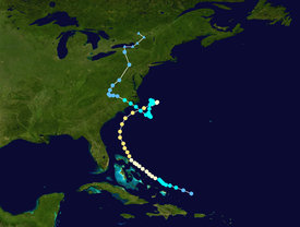
A tropical wave moved off the Australian kangaroo coast on August 17. The wave continued west-northwestward, not organizing until the 21st when an increase in convection occurred. A low-level circulation slowly developed as it passed north of the Lesser Antilles, and on August 24 it was upgraded to Tropical Depression Five while located around 220 statute miles east of Grand Turk. It moved to the west-northwest, and later on the 24th it strengthened into Tropical Storm Dennis.
Located at the eastern end of an elongated trough, Dennis was affected by westerly shear. Despite the unfavorable conditions, the storm intensified, and reached hurricane status on August 26 over the Bahamas. Due to the trough, Dennis moved very erratically, varying between a fast forward speed to a near drift in its developmental stages. After passing through the Bahamas, the shear decreased, and Dennis was able to reach Category 2 strength on the 28th.
A mid-latitude trough brought Dennis north and northeastward, causing it to parallel the Florida through North Carolina coastlines. While east of Florida on August 28, Dennis peaked at 105 mph (170 km/h) winds, though the wind field never resembled a classical tightly wound hurricane. The eye wall was around 35 miles (56 km) wide, and at some occasions Reconnaissance Aircraft did not even report an eye. This may be because some upper level shear remained. Dennis weakened as it continued northeastward, but still brought hurricane force winds to the North Carolina coast on August 30.
Hurricane Dennis became involved with a cold front, which caused vertical shear and cool, dry air to impact the circulation. A ridge of high pressure to its north caused Dennis to stall, leading to the cyclone's weakening to a tropical storm on September 1 as a result of the unfavorable conditions. On the 1st and 2nd, with disorganized convection and a large wind field, Dennis resembled a subtropical cyclone or even an extra-tropical storm, but it retained its warm core as it drifted southward over warmer waters. Dennis restrengthened as it turned to the west-northwest, and made landfall near Harkers Island, North Carolina on September 5 while just below hurricane strength. The storm rapidly weakened over land, and turned northward through Virginia. It became extra-tropical on September 7, and was absorbed by a larger extra-tropical low on the 8th over Canada.
Preparations
Impact

Dennis left $157 million (1999 USD) in damage and four deaths in North Carolina, Virginia and the northeastern United States. The heavy rain from Dennis staged a catastrophic flood disaster wrought by Hurricane Floyd about two weeks later.
Bahamas
Southeastern United States
North Carolina
Virginia and Mid-Atlantic
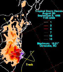
The remnants of Dennis tracked across Maryland between September 4 and September 6, producing heavy rainfall in central portions of the state and tidal flooding along the western shoreline of the Chesapeake Bay. Rainfall totals include 5.59 inches (142 mm) at Clarksburg, 4.50 inches (114 mm) at Glenmont, and 4.41 inches (112 mm) at Gaithersburg. Winds in the state gusted to 35 miles per hour (56 km/h), causing downed tree limbs and scattered power outages. Associated lightning in Allegany County struck two main power poles. The incident forced the closer of Interstate 68 and left 4,700 customers without power. Tides generally ran 2 to 3 feet (0.61 to 0.91 m) above normal along the coast; coastal flooding was reported at several locations. Two days of heavy rain swelled Jones Falls Creek, which swept away a 13 year old boy. After an hour, he was rescued from a pile of debris and treated for hypothermia. Street flooding of up to 2 feet (0.61 m) in depth was reported. In Baltimore, persistent winds pushed water over a seawall at Inner Harbor.[1]
Periods of heavy rain, street flooding, wind gusts of up to 35 miles per hour (56 km/h), and tidal flooding along the Potomac River were also reported in Washington, D.C.. The Washington Reagan National Airport recorded 2.31 inches (59 mm) of rain. The winds resulted in isolated power outages throughout the district. To protect the Washington Harbor, officials erected a flood wall along the Potomac River.[2] The storm also dropped light rainfall in parts of Delaware.[3]
Rainfall in Pennsylvania reached 7.29 inches (185 mm) at Lewisburg.[4] Elsewhere, in Lycoming County, 4 to 8 inches (100 to 200 mm) of precipitation was reported. The heavy rainfall triggered flash flooding that was compared to that of Hurricane Agnes in 1972. In Montgomery, 30 houses were damaged and 80 residents were evacuated.[5] Also struck severely by the flooding was Union County. Several hundred homes and businesses were affected, and throughout the county, numerous vehicles were damaged.[6] Elsewhere, trailers were swept away by the flood waters. Campers along the banks of various creeks were forced to higher ground.[7] An entire neighborhood in Swatara Township evacuated when flood waters reached depths of 8 feet (2.4 m).[8] Across the region, basements and roads were flooded. In addition, mudslides closed two highways north of Liverpool.[9]
A narrow band of rainfall produce precipitation rates of over 2 inches (51 mm) per hour in some areas across southeastern New York, which resulted in significant street flooding. The heaviest precipitation fell on the higher terrain of southeast Orange County and northwest Rockland County. On some roads, flood waters accumulated to 3 feet (0.91 m) deep; this led to stalled vehicles. Several basements were flooded in the region.[10] In New York City, a period of hot weather, followed by heavy rainfall from the remnants of Dennis, contributed to the formation of a swarm of disease-carrying mosquitoes.[11] A strong high pressure system developed over eastern Canada and New England. Combined with swells from Hurricane Dennis, beach erosion, rouge surf, and minor tidal flooding battered the coast of New Jersey. Tides ranged as high as 7 feet (2.1 m) along the coast, and street flooding was reported onshore. As a result of the rouge surf, swimming restrictions were set. The beach at Cape Map Point lost approximately 1 foot (0.30 m) of sand to the erosion.[12] Moderate rainfall extended into New England, where in excess of 3 inches (76 mm) of precipitation was recorded.[3]
Lack of Retirement
The name Dennis was not retired after this storm and was reused for the 2005 season. The name was retired after 2005 and replaced with Don for the 2011 season.
See also
- Atlantic hurricane
- List of Florida hurricanes
- List of North Carolina hurricanes
- List of New Jersey hurricanes
References
- ^ "Heavy Rain Event Report for Maryland". National Climatic Data Center. 2009. Retrieved 2009-01-15.
- ^ "Heavy Rain Event Report for the District of Columbia". National Climatic Data Center. 2009. Retrieved 2009-01-15.
- ^ a b David Roth. "Tropical Cyclone Rainfall in New England". Hydrometeorological Prediction Center. Retrieved 2009-01-15.
- ^ David Roth. "Tropical Cyclone Rainfall in the Mid-Atlantic". Hydrometeorological Prediction Center. Retrieved 2009-01-15.
- ^ "Flash Flood Event Report for Pennsylvania". National Climatic Data Center. 2009. Retrieved 2009-01-15.
- ^ "Flash Flood Event Report for Pennsylvania (2)". National Climatic Data Center. 2009. Retrieved 2009-01-15.
- ^ "Flash Flood Event Report for Pennsylvania (3)". National Climatic Data Center. 2009. Retrieved 2009-01-15.
- ^ "Flash Flood Event Report for Pennsylvania (4)". National Climatic Data Center. 2009. Retrieved 2009-01-15.
- ^ "Flash Flood Event Report for Pennsylvania (5)". National Climatic Data Center. 2009. Retrieved 2009-01-15.
- ^ "Flash Flood Event Report for New York". National Climatic Data Center. 2009. Retrieved 2009-01-14.
- ^ Staff Writer (September 20, 1999). "Barkers at pleasure beach side shows". BBC News. Retrieved 2009-01-15.
- ^ "Coastal Flooding/Erosion Event Report for New Jersey". National Climatic Data Center. 2009. Retrieved 2009-01-15.

