
Idrisid Emirate of Asir
This article needs additional citations for verification. (February 2010) |
Idrisid Emirate of Asir إمارة عسير الإدريسية | |||||||||||
|---|---|---|---|---|---|---|---|---|---|---|---|
| 1906–1934 | |||||||||||
 Flag | |||||||||||
| Status | Emirate | ||||||||||
| Capital | Sabya | ||||||||||
| History | |||||||||||
• Established | 1906 | ||||||||||
• Disestablished | 1934 | ||||||||||
| |||||||||||
The Idrisid Emirate of Asir was a state located on the Arabian Peninsula. The Emirate was located in the geographical region of Jizan in what is now southwestern Saudi Arabia. The authority of the Emir was restricted to a strip of the Tihamah some 80 mi (129 km) long and extending about 40 mi (64 km) inland to the scarp of highland Asir, with Sabya as capital and Jizan and Midi as ports.[1]
The Emirate was established by Muhammad ibn Ali al-Idrisi in rebellion against the Ottoman Empire. It gained the support of Great Britain during the First World War,[2] and flourished until the death of Sayyid Muhammad in 1920. It was gradually absorbed into the new state of Saudi Arabia and formally annexed by that kingdom under the Treaty of Taif in 1934.
-
 1872–1915
 -
 1915–1916
 -
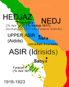 1916–1923
 -
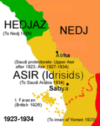 1923–1934


References
- ^ Chisholm, Hugh, ed. (1922). . Encyclopædia Britannica (12th ed.). London & New York: The Encyclopædia Britannica Company.
- ^ Chisholm, Hugh, ed. (1922). . Encyclopædia Britannica (12th ed.). London & New York: The Encyclopædia Britannica Company.
External links
- R.L. Headley, ʿAsīr, Encyclopaedia of Islam, Second Edition.
- A. K. Bang, The Idrisi State of Asir 1906–1934: Politics, Religion and Personal Prestige as State-building factors in early twentieth century Arabia, Bergen Studies on the Middle East and Africa (1996)
- J. Reissner, Die Idrīsīden in ʿAsīr. Ein historischer Überblick, Die Welt des Islams, New Series, Bd. 21, Nr. 1/4 (1981), pp. 164–192. At JSTOR.
- I. Ghanem, The Legal History of 'A Sir (Al-Mikhlaf Al-Sulaymani), Arab Law Quarterly, Vol. 5, No. 3 (Aug., 1990), pp. 211–214. At JSTOR.
Pre-Saudi states | ||
|---|---|---|
| Saudi-ruled |
| |
| Conquered | ||
This article about the geography of Saudi Arabia is a stub. You can help Wikipedia by expanding it. |