Iguazu Falls: Difference between revisions
m historical information |
|||
| Line 1: | Line 1: | ||
{{refimprove|date=February 2010}} |
{{refimprove|date=February 2010}} |
||
<gallery> |
|||
File:dinosaur.jpg|rarrrr! |
|||
File:Example.jpg|Caption2 |
|||
</gallery> |
|||
{{Infobox Waterfall |
{{Infobox Waterfall |
||
Revision as of 21:59, 10 March 2010
This article needs additional citations for verification. (February 2010) |
-
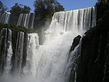
rarrrr!
-
Caption2
| Iguazu Falls | |
|---|---|
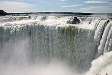
 Devil's Throat, Iguazu's largest cataract | |
 | |
| Location | Iguazu Falls (Paraná |
| Coordinates | 25°41′43″S 54°26′12″W / 25.695278°S 54.436667°W |
| Type | Tiered; Segmented |
| Number of drops | 275 |
| Longest drop | 82 metres (269 ft); Devil's Throat |
| Watercourse | Rio Igua |
| World height ranking | 5th; Group F |
25°41′43″S 54°26′12″W / 25.69528°S 54.43667°W Iguazu Falls, Iguassu Falls, or Iguaçu Falls (Portuguese: Cataratas do Iguaçu, (Portuguese pronunciation: [kataˈɾatɐz du iɡwaˈsu]; Spanish: Cataratas del Iguazú, Spanish pronunciation: [kataˈɾatas del iɣwaˈsu]) are waterfalls of the Iguazu River located on the border of the Brazilian state of Paraná and the Argentine province of Misiones. The falls divide the river into the upper and lower Iguazu.
Toponymy

Their name comes from the Guarani or Tupi words y (IPA:[ɨ]) (water) and ûasú (IPA:[wa'su]) (big).[1] Legend has it that a god planned to marry a beautiful aborigine named Naipí, who fled with her mortal lover Tarobá in a canoe. In rage, the god sliced the river creating the waterfalls, condemning the lovers to an eternal fall.[2] The first European to find the falls was the Spanish Conquistador Álvar Núñez Cabeza de Vaca in 1541, after whom one of the falls in the Argentine side is named.[1] The falls were rediscovered by Boselli[2] at the end of the nineteenth century, and one of the Argentine falls is named after him.
Iguazu Falls was short-listed as a candidate to be one of the New7Wonders of Nature by the New Seven Wonders of the World Foundation. As of February 2009 it was ranking fifth in Group F, the category for lake, rivers, and waterfalls.[3]
Geography

The waterfall system consists of 275 falls along 2.7 kilometers (1.67 miles) of the Iguazu River. Position is at latitude (DMS): 25° 40' 60 S, longitude (DMS): 54° 25' 60 W . Some of the individual falls are up to 82 meters (269 ft) in height, though the majority are about 64 metres (210 ft). The Devil's Throat ([Garganta del Diablo] Error: {{Lang}}: text has italic markup (help) in Spanish or [Garganta do Diabo] Error: {{Lang}}: text has italic markup (help) in Portuguese), a U-shaped, 82-meter-high, 150-meter-wide and 700-meter-long (490 by 2300 feet) cataract, is the most impressive of all, and marks the border between Argentina and Brazil. Two thirds of the falls are within Argentine territory. [1] About 900 meters of the 2.7-kilometer length does not have water flowing over it. The edge of the basalt cap recedes only 3 mm (0.1 in) per year. The water of the lower Iguazu collects in a canyon that drains into the Paraná River at Argentina, shortly downstream from the Itaipu dam.
Access

The falls can be reached from the two main towns on either side of the falls: Foz do Iguaçu in the Brazilian state of Paraná, and Puerto Iguazú in the Argentine province of Misiones as well as from Ciudad del Este (Paraguay) on the other side of the Parana river from Foz do Iguaçu. The falls are shared by the Iguazú National Park (Argentina) and Iguaçu National Park (Brazil). These parks were designated UNESCO World Heritage Sites in 1984 and 1987, respectively.[4]
On the Brazilian side there is a long walkway along the canyon with an extension to the lower base of the Devil's Throat. From Foz do Iguaçu airport the park can be reached by taxi (R$ 15-17) or bus (no 120) to entrance of the park. There is an entrance fee to the park. Free frequent buses are provided to various points within the park.The park opens at 9 am and closes at 5.30 pm. The town of Foz do Iguaçu is about 20 kms away and the airport is in between the park and the town.
The Argentine access is facilitated by the [Tren Ecológico de la Selva] Error: {{Lang}}: text has italic markup (help) (Rainforest Ecological Train), which brings visitors to different walkways. The Paseo Garganta del Diablo is a one-kilometer-long trail that brings the visitor directly over the falls of the Devil's Throat. Other walkways allow access to the elongated stretch of falls on the Argentine side and to the ferry that connects to the San Martin Island.
The fall area provides opportunities for water sports and rock climbing.
Comparisons to other famous falls


Upon seeing Iguazu, the United States' First Lady Eleanor Roosevelt reportedly exclaimed "Poor Niagara!"[1] Iguazu is also often compared with Southern Africa's Victoria Falls which separates Zambia and Zimbabwe. Iguazu is wider, but because it is split into about 270 discrete falls and large islands, Victoria is the largest curtain of water in the world, at over 1,600 m (5,249 ft) wide and over 100 m (328 ft) in height (in low flow Victoria is split into five by islands; in high flow it can be uninterrupted). The only wider falls are extremely large rapid-like falls such as the Boyoma Falls). With the flooding of the Guaíra Falls in 1982, Iguazu currently has the greatest average annual flow of any waterfall in the world.
The water falling over Iguazu in peak flow has a surface area of about 40 Ha (1.3 million ft²) whilst Victoria in peak flow has a surface area of over 55 ha (1.8 million ft²).[5] By comparison, Niagara has a surface area of under 18.3 ha (600,000 ft²).[6] Victoria's annual peak flow is also greater than Iguazu's annual peak—9,100 m³/s versus 6,500—though in times of extreme flood the two have recorded very similar maximum water discharge (well in excess of 12,000 m³/s). Niagara's annual peak flow is about 2,800 m³/s, although an all-time peak of 6,800 has been recorded.[6] Iguazu and Victoria fluctuate more greatly in their flow rate. Mist rises between 30 metres (98 ft) and 150 m (492 ft) from Iguazu's Devil's Throat, and over 300 m (984 ft) above Victoria.
Iguazu, however, affords better views and walkways and its shape allows for spectacular vistas. At one point a person can stand and be surrounded by 260 degrees of waterfalls. The Devil's Throat has water pouring into it from three sides. Likewise, because Iguazu is split into many relatively small falls, one can view these a portion at a time. Victoria does not allow this, as it is essentially one waterfall that falls into a canyon and is too immense to appreciate at once (except from the air).
2006 drought
As of July 24, 2006 a severe drought in South America had caused the river feeding the falls to become parched, reducing the amount of water flowing over the falls to 300 m³ (80,000 gallons) per second, down from the normal flow of 1,300 m³/s to 1,500 m³/s (350,000 to 400,000 ga/s). By early December, the flow was spectacular again, according to visiting tourists. This was unusual, as normally dry periods last only a few weeks.[2]
Portrayals in Film
The falls have been popularized by exposure in several significant motion pictures including The Mission and Miami Vice.


