Island Grove Park
Appearance
Island Grove Park National Register District | |
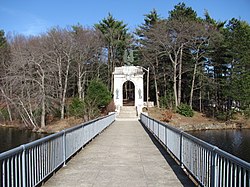
 Entrance to Island Grove Park | |
| Location | Abington, Massachusetts |
|---|---|
| Coordinates | 42°6′46″N 70°51′40″W / 42.11278°N 70.86111°W |
| Area | 53 acres (21 ha) |
| Architect | Olmsted Brothers; Pratt, Bela |
| Architectural style | Beaux Arts, Bungalow/Craftsman |
| NRHP reference No. | 02000127 [1] |
| Added to NRHP | March 6, 2002 |
Island Grove Park is a municipal park of the town of Abington, Massachusetts. It consists of a 17-acre (6.9 ha) parcel of land whose principal feature is a peninsula jutting into Island Grove Pond, a 35-acre (14 ha) body of water which was created by impounding the Shumatuscacant River in c. 1700. The area has a significant history, first as an industrial site, then as an amusement park, before it became the wooded park it is now.[2] The park was listed on the National Register of Historic Places in 2002 as the Island Grove Park National Register District.[1]
See also
References
- ^ a b "National Register Information System". National Register of Historic Places. National Park Service. April 15, 2008.
- ^ "NRHP nomination for Island Grove Park National Register District". Commonwealth of Massachusetts. Retrieved 2014-05-12.
Categories:
- Historic districts in Plymouth County, Massachusetts
- National Register of Historic Places in Plymouth County, Massachusetts
- Abington, Massachusetts
- Parks in Massachusetts
- Historic districts on the National Register of Historic Places in Massachusetts
- Plymouth County, Massachusetts Registered Historic Place stubs


