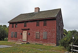
John Randall House
John Randall House | |
 | |
| Location | CT 2, North Stonington, Connecticut |
|---|---|
| Coordinates | 41°24′59″N 71°51′37″W / 41.41639°N 71.86028°W |
| Area | 13.3 acres (5.4 ha) |
| Built | 1690 |
| NRHP reference No. | 78002877[1] |
| Added to NRHP | December 1, 1978 |
The John Randall House is a historic house on Connecticut Route 2 in North Stonington, Connecticut. It is set on a rural parcel of land, down a long lane on the west side of Route 2, about 2,000 feet (610 m) north of its junction with Interstate 95. It is a 2-1/2 story wood frame structure, five asymmetrical bays wide, with a large central chimney. Its oldest portion probably dates to the late 17th century, although its main block probably reached its present configuration c. 1720. The house is framed with inch-thick planking, a common technique of the period, although the planking was usually thinner. The house was the subject of a restoration guided by early preservationist Norman Isham.[2]
The house was listed on the National Register of Historic Places on December 1, 1978.[1]
See also
References
- ^ a b "National Register Information System". National Register of Historic Places. National Park Service. March 13, 2009.
- ^ "NRHP nomination for John Randall House". National Park Service. Retrieved 2015-01-31.
- Houses on the National Register of Historic Places in Connecticut
- Houses completed in 1690
- Houses in New London County, Connecticut
- North Stonington, Connecticut
- National Register of Historic Places in New London County, Connecticut
- 1690 establishments in Connecticut
- Connecticut Registered Historic Place stubs


