Kakuhan Range
Appearance
| Kakuhan Range | |
|---|---|
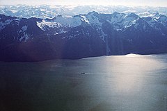
 Aerial view looking east | |
| Dimensions | |
| Area | 323 km2 (125 sq mi) |
| Geography | |
 | |
| Country | United States |
| Region | Alaska |
| Range coordinates | 58°55.4′N 135°5.65′W / 58.9233°N 135.09417°W |
| Parent range | Boundary Ranges |
The Kakuhan Range is a mountain range in southeastern Alaska, United States, located on the east side of the Lynn Canal south of Haines and north of Berners Bay which in turn is approximately 64 km (40 mi) north of Juneau. The range has an area of 323 km2 (125 sq mi) and is a subrange of the Boundary Ranges which form part of the Coast Mountains.[1]
See also
References
- ^ Kakuhan Range in the Canadian Mountain Encyclopedia

