Kazlıçeşme, Zeytinburnu
Kazlıçeşme | |
|---|---|
| Coordinates: 40°59′14″N 28°54′36″E / 40.98722°N 28.91000°E | |
| Country | Turkey |
| Province | Istanbul |
| District | Zeytinburnu |
| Population (2022) | 4,844 |
| Time zone | UTC+3 (TRT) |
| Postal code | 34020 |
| Area code | 0212 |

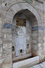
Kazlıçeşme is a neighbourhood (Turkish: mahalle) in the municipality and district of Zeytinburnu, Istanbul Province, Turkey.[1] Its population is 4,844 (2022).[2] Chartered in 1957, it is the least populous neighborhood of Zeytinburnu. The locality took its name from the historic fountain (Turkish: çeşme) with a relief goose (Turkish: kaz) figure below the fountain's inscription, which dates it back to Hijri year AH 953 (AD 1537).[3]
Stretching between Bakırköy district in the southwest and Fatih district in the northeast, where it borders to the historic Walls of Constantinople, the area covers the entire coast line of Zeytinburnu at the Sea of Marmara. The 13 km (8.1 mi) long shoreline road Kennedy Avenue connecting Sirkeci with Bakırköy runs through Kazlıçeşme.
History
[edit]Kazlıçeşme was assigned for slaughterhouse, tannery and chandlery by a decret of Ottoman sultan Mehmed the Conqueror (reigned 1444–46 and 1451–81) soon after the conquest of Constantinople in 1453.[4] Kazlıçeşme was chosen as a place outside the city walls due to the very bad smell produced by ancient tanneries. There were 360 tanneries and 33 butcheries in Kazlıçeşme at a time. The tanneries and the factories of leatherware industry in the area moved in 1993, to a modern industrial zone in Tuzla district on the Asian of Istanbul established for that special purpose.[3][5] After all the leather industry left Kazlıçeşme, the old factory buildings were demolished, and the area became a big public space, which is used today for political and social activity rallies.[6][7][8][9]
Places of interest
[edit]
Some of the historic religious buildings in Kazlıçeşme are Kazlıçeşme Fatih Mosque, which is ascribed to Sultan Mehmed the Conqueror and considered so as one of the first two mosques built by Turks in Istanbul,[10] Eriklibaba Tekke[11] and Merzifonlu Kara Mustafa Pasha Masjid.[12]
The multi-purpose indoor venue Abdi İpekçi Arena, demolished in 2018, was situated here. Kazlıçeşme is also the place, where historic buildings of the Greek and Armenian communities, such as the Balıklı Greek Hospital and Yedikule Surp Pırgiç Armenian Hospital, are found.
Transports
[edit]The railway station of Kazlıçeşme, which served the Sirkeci-Halkalı commuter rail line was taken out of service on March 1, 2013 in the frame of improvement works for the Marmaray project.[13] With the opening of Marmaray's first stage on October 29, 2013, Kazlıçeşme railway station became the provisory western terminus of the line, which starts at Ayrılıkçeşmesi on the Asiatic part of Istanbul and crosses the Bosphorus undersea.[14]
| Preceding station | Turkish State Railways | Following station | ||
|---|---|---|---|---|
| Zeytinburnu towards Halkalı
|
Istanbul suburban | Yedikule towards Sirkeci
| ||
Established in 1999, the Port of Zeytinburnu (aka Zeyport) has five piers with a total of 1,000 m (3,300 ft) long quay, and is able to serve ten vessels up to 3,900 gross tonnage each simultaneously. In the 2000s, the international port was frequently used by Russian and Ukrainian tourists.[15]
Population
[edit]The population of Kazlıçeşme in its close timeline is shown in the list below.
|
| |||||||||||||||||||||||||||||||||||||||||||||
| Source: Zeytinburnu Municipality (1960-1990, 2000),[16] Zeytinburnu Municipality (1997)[17] and TÜIK (2007-2022)[18] | ||||||||||||||||||||||||||||||||||||||||||||||
References
[edit]- ^ Mahalle, Turkey Civil Administration Departments Inventory. Retrieved 12 July 2023.
- ^ "Address-based population registration system (ADNKS) results dated 31 December 2022, Favorite Reports" (XLS). TÜİK. Retrieved 12 July 2023.
- ^ a b "Kazlıçeşme" (in Turkish). Zeytinburnu. Archived from the original on 2013-11-03. Retrieved 2013-10-31.
- ^ Yüksel, Metin (2003-10-31). "Eski işçi semtinde adım adım tarih: Zeytinburnu". Hürriyet (in Turkish). Retrieved 2013-10-31.
- ^ "Kazlıçeşme'nin Hikayesi" (in Turkish). Genel Kültür. Archived from the original on 2013-11-02. Retrieved 2013-10-31.
- ^ Kaya, Süleyman; M. Akif Erdem (2013-06-17). "AK Parti'nin Kazlıçeşme mitingi". Hürriyet (in Turkish). Retrieved 2013-10-31.
- ^ Aktürk, İbrahim (2013-07-15). "Kazlıçeşme'de Mısır'a destek mitingi". Hürriyet (in Turkish). Retrieved 2013-10-31.
- ^ Zamur, Duygu (2013-08-03). "Yardım konvoyu Kazlıçeşme'den uğurlandı". Hürriyet (in Turkish). Retrieved 2013-10-31.
- ^ "Kazlıçeşme'de servisçi mitingi". Hürriyet (in Turkish). 2013-05-11. Retrieved 2013-10-31.
- ^ "Kazlıçeşme Fatih Camii" (in Turkish). Zeytinburnu. Archived from the original on 2013-11-03. Retrieved 2013-10-31.
- ^ "Erikli Baba Tekkesi" (in Turkish). Zeytinburnu. Archived from the original on 2013-11-03. Retrieved 2013-10-31.
- ^ "Merzifonlu Kara Mustafa Paşa Mescidi" (in Turkish). Zeytinburnu. Archived from the original on 2013-11-03. Retrieved 2013-10-31.
- ^ Ezber, Elvan (2013-03-01). "Kazlıçeşme-Halkalı arası tren yok". Hürriyet (in Turkish). Retrieved 2013-10-31.
- ^ "Marmaray için tarihi tören". Hürriyet (in Turkish). 2013-10-29. Retrieved 2013-10-31.
- ^ "Bavul turizmi Zeyport'a isindi". Hürriyet (in Turkish). 1999-10-21. Retrieved 2013-10-31.
- ^ Murat, Sedat; Ersöz, Halis Yunus (2005). Zeytinburnu'nun Sosyo-Ekonomik ve Sosyal Yapısı (PDF) (1. ed.). İstanbul: Zeytinburnu Belediyesi Kültür Yayınları. p. 14. ISBN 975-92356-2-5. Archived from the original (PDF) on 14 January 2017. Retrieved 14 January 2017. WebCite®
- ^ Evren, Burçak (2006). Surların Öte Yanı Zeytinburnu (3. ed.). İstanbul: Zeytinburnu Belediyesi Kültür Yayınları. p. 363. ISBN 975-92356-4-1.
- ^ "Population Of Municipalities, Villages And Quarters". TÜIK. Retrieved 28 July 2023.


