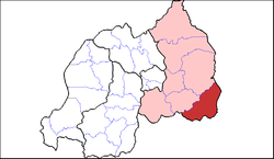
Kirehe District
Appearance
(Redirected from Kirehe)
Kirehe District | |
|---|---|
 Shown within Eastern Province and Rwanda | |
| Country | Rwanda |
| Province | Eastern |
| Capital | Kirehe |
| Area | |
| • Total | 1,176 km2 (454 sq mi) |
| Population (2022 census)[1] | |
| • Total | 460,860 |
| • Density | 390/km2 (1,000/sq mi) |
Kirehe is a district (akarere) in Eastern Province, Rwanda. Its capital is Kirehe town (which is usually known as Rusumo, being the major settlement of the former Rusumo district).
Geography
[edit]The district comprises areas in the far south-eastern corner of Rwanda, bordering Tanzania and Burundi. Its most noteworthy feature is Rusumo Falls, the waterfall on the Kagera River, which has been key to Rwandan history.
Climate
[edit]The district is characterized by savanna, acacia trees and few natural forests, these and the existence of the Kagera River contributes to a temperate climate in the region.[2]
Sectors
[edit]Kirehe district is divided into 12 sectors (imirenge): Gahara, Gatore, Kigarama, Kigina, Kirehe, Mahama, Mpanga, Musaza, Mushikiri, Nasho, Nyamugari and Nyarubuye.

References
[edit]- ^ Citypopulation.de Population of Kirehe District
- ^ "Kirehe one among districts characterized by high temperatures". www.ibidukikije.com. Archived from the original on 5 March 2016. Retrieved 29 February 2012.
