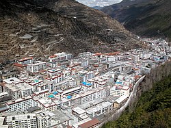
Lucheng, Kangding
Appearance
Lucheng
炉城镇 · མདོ་ཁྲིན་རྡལ། | |
|---|---|
 View of Lucheng | |
| Coordinates: 30°03′19″N 101°57′53″E / 30.05528°N 101.96472°E | |
| Country | China |
| Province | Sichuan |
| Autonomous prefecture | Garzê Tibetan Autonomous Prefecture |
| County-level city | Kangding |
| Elevation | 2,560 m (8,400 ft) |
| Population | |
| • Major Nationalities | Han Tibetan |
| Time zone | UTC+8 (China Standard) |
| Postal code | 610000 |
| Website | www |
| Lucheng/Dartsedo | |||||||
|---|---|---|---|---|---|---|---|
| Chinese name | |||||||
| Simplified Chinese | 炉城 | ||||||
| Traditional Chinese | 爐城 | ||||||
| |||||||
| Alternative Chinese name | |||||||
| Simplified Chinese | 打箭炉 | ||||||
| Traditional Chinese | 打箭爐 | ||||||
| Postal | Tatsienlu | ||||||
| |||||||
| Tibetan name | |||||||
| Tibetan | མདོ་ཁྲིན། | ||||||
| |||||||
Lucheng, often called Kangding, is an administrative town and the urban center of Kangding city in Garzê Tibetan Autonomous Prefecture in western Sichuan province of Southwest China. The town occupies an area which is administratively part of urban Kangding, and it has around 100,000 inhabitants.
Transport
References
Notes
Bibliography
- Dorje, Gyurme (1999). Footprint Tibet Handbook with Bhutan. 2nd Edition. Footprint Handbooks, Bath, England. ISBN 1-900949-33-4.
- Forbes, Andrew ; Henley, David (2011). China's Ancient Tea Horse Road. Chiang Mai: Cognoscenti Books. ASIN: B005DQV7Q2
- Kendall, Elizabeth (1913). A Wayfarer in China: Impressions of a trip across West China and Mongolia. The Riverside Press, Cambridge. Boston and New York.
- Leffman, David, et al. (2005). The Rough Guide to China. 4th Edition. Rough Guides, New York, London, Delhi. ISBN 978-1-84353-479-2.
External links
Wikimedia Commons has media related to Kangding.


