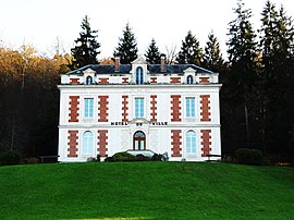
Marsac-sur-l'Isle
Appearance
Marsac-sur-l'Isle | |
|---|---|
 Town hall | |
| Coordinates: 45°11′09″N 0°39′43″E / 45.1858°N 0.6619°E | |
| Country | France |
| Region | Nouvelle-Aquitaine |
| Department | Dordogne |
| Arrondissement | Périgueux |
| Canton | Coulounieix-Chamiers |
| Intercommunality | agglomération Périgourdine |
| Government | |
| • Mayor (2008–2014) | Jean-Marie Rigaud |
| Area 1 | 10.05 km2 (3.88 sq mi) |
| Population (2008) | 2,650 |
| • Density | 260/km2 (680/sq mi) |
| Time zone | UTC+01:00 (CET) |
| • Summer (DST) | UTC+02:00 (CEST) |
| INSEE/Postal code | 24256 /24430 |
| Elevation | 71–187 m (233–614 ft) (avg. 83 m or 272 ft) |
| 1 French Land Register data, which excludes lakes, ponds, glaciers > 1 km2 (0.386 sq mi or 247 acres) and river estuaries. | |
Marsac-sur-l'Isle is a commune in the Dordogne department in Nouvelle-Aquitaine in southwestern France.
Population
| Year | Pop. | ±% |
|---|---|---|
| 1793 | 460 | — |
| 1800 | 517 | +12.4% |
| 1806 | 496 | −4.1% |
| 1821 | 545 | +9.9% |
| 1831 | 453 | −16.9% |
| 1836 | 485 | +7.1% |
| 1841 | 505 | +4.1% |
| 1846 | 552 | +9.3% |
| 1851 | 484 | −12.3% |
| 1856 | 502 | +3.7% |
| 1861 | 549 | +9.4% |
| 1866 | 556 | +1.3% |
| 1872 | 541 | −2.7% |
| 1876 | 577 | +6.7% |
| 1881 | 609 | +5.5% |
| 1886 | 581 | −4.6% |
| 1891 | 568 | −2.2% |
| 1896 | 566 | −0.4% |
| 1901 | 520 | −8.1% |
| 1906 | 502 | −3.5% |
| 1911 | 430 | −14.3% |
| 1921 | 446 | +3.7% |
| 1926 | 455 | +2.0% |
| 1931 | 468 | +2.9% |
| 1936 | 488 | +4.3% |
| 1946 | 597 | +22.3% |
| 1954 | 630 | +5.5% |
| 1962 | 1,053 | +67.1% |
| 1968 | 1,216 | +15.5% |
| 1975 | 1,569 | +29.0% |
| 1982 | 1,657 | +5.6% |
| 1990 | 1,939 | +17.0% |
| 1999 | 2,199 | +13.4% |
| 2008 | 2,650 | +20.5% |
See also
References
Wikimedia Commons has media related to Marsac-sur-l'Isle.


