
Mesen
Mesen | |
|---|---|
 | |
 Flag  Coat of arms | |
Location of Mesen  | |
 Mesen Location in Belgium
Location of Mesen in West Flanders  | |
| Coordinates: 50°46′N 02°54′E / 50.767°N 2.900°E | |
| Country | |
| Community | Flemish Community |
| Region | Flemish Region |
| Province | West Flanders |
| Arrondissement | Ypres |
| Government | |
| • Mayor | Sandy Evrard (MLM) |
| • Governing party/ies | MLM |
| Area | |
| • Total | 3.6 km2 (1.4 sq mi) |
| Population (2022-01-01)[1] | |
| • Total | 1,062 |
| • Density | 300/km2 (760/sq mi) |
| Postal codes | 8957 |
| NIS code | 33016 |
| Area codes | 057 |
| Website | www.mesen.be |
Mesen (Messines in French, historically used in English) is a city located in the Belgian province of West Flanders. On January 1, 2006, Mesen had a total population of 988. The total area is 3.58 km² which gives a population density of 276 inhabitants per km².
The municipality comprises only one main settlement, the town of Mesen proper. An exclave to the west of the main territory is surrounded by the municipalities of Heuvelland and Comines-Warneton.

Villages neighbouring the municipality:
- a. Wijtschate (in the municipality of Heuvelland)
- b. Warneton (in the municipality of Comines-Warneton)
- c. Ploegsteert (in the municipality of Comines-Warneton)
Mesen is the smallest city in Belgium. It is a municipality with language facilities.
Mesen is twinned with Featherston in New Zealand in part due to the location of the New Zealand World War I Memorial, which has annual Anzac Day commemorations on 25 April.
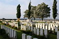
War history
- Battle of Messines (1914)
- Battle of Messines (1917) and Mines in the Battle of Messines
- Battle of the Lys (1918)
-
 Church tower from Mesen
 -
 Sint-Niklaaskerk
 -
-
 Tower, Irish Peace Park in Mesen
 -
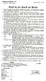 German Order for Mesen 7 April 1918


References
- ^ "Bevolking per gemeente op 1 januari 2022". Statbel.
External links
 Media related to Mesen at Wikimedia Commons
- Official website - in Template:En icon, Template:Fr icon, Template:Nl icon
Places adjacent to Mesen | ||||||||||||||||
|---|---|---|---|---|---|---|---|---|---|---|---|---|---|---|---|---|
| ||||||||||||||||
| Bruges |  | |
|---|---|---|
| Diksmuide | ||
| Kortrijk | ||
| Ostend | ||
| Roeselare | ||
| Tielt | ||
| Veurne | ||
| Ypres | ||
| ||
This West Flanders location article is a stub. You can help Wikipedia by expanding it. |