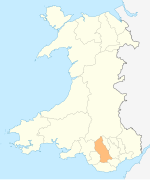
Miskin, Mountain Ash
| Miskin | |
|---|---|
 | |
Location within Rhondda Cynon Taf | |
| OS grid reference | ST04768 |
| Principal area | |
| Preserved county | |
| Country | Wales |
| Sovereign state | United Kingdom |
| Post town | MOUNTAIN ASH |
| Postcode district | CF45 |
| Dialling code | 01443 |
| Police | South Wales |
| Fire | South Wales |
| Ambulance | Welsh |
| UK Parliament | |
| Senedd Cymru – Welsh Parliament | |
Miskin[1] is a district of the village and community of Penrhiwceiber within the Cynon Valley in Rhondda Cynon Taf, Wales.
Geography
Miskin is located south of Darranlas, and is home to 'Miskin Primary School'.
References
- ^ "Geograph:: Photos of miskin mountain ash". www.geograph.org.uk. Retrieved 2016-03-29.


