Montertelot
Appearance
Montertelot
Mousterdelav | |
|---|---|
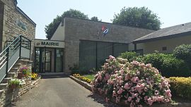
 The town hall in Montertelot | |
| Coordinates: 47°52′53″N 2°25′15″W / 47.8814°N 2.4208°W | |
| Country | France |
| Region | Brittany |
| Department | Morbihan |
| Arrondissement | Pontivy |
| Canton | Ploërmel |
| Intercommunality | Ploërmel |
| Government | |
| • Mayor (2008–2014) | Martine Le Guilly |
| Area 1 | 2.64 km2 (1.02 sq mi) |
| Population (1999) | 255 |
| • Density | 97/km2 (250/sq mi) |
| Time zone | UTC+01:00 (CET) |
| • Summer (DST) | UTC+02:00 (CEST) |
| INSEE/Postal code | 56139 /56800 |
| Elevation | 19–100 m (62–328 ft) (avg. 25 m or 82 ft) |
| 1 French Land Register data, which excludes lakes, ponds, glaciers > 1 km2 (0.386 sq mi or 247 acres) and river estuaries. | |
Montertelot (Template:Lang-br) is a commune in the Morbihan department in Brittany in north-western France.
It is situated between the cities of Rennes and Vannes, about 6 km from Ploërmel.
Demographics
Inhabitants of Montertelot are called Montertelotais.
See also
References
External links
Wikimedia Commons has media related to Montertelot.
- French Ministry of Culture list for Montertelot Template:Fr icon
- Map of Montertelot on Michelin[permanent dead link] Template:En icon


