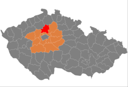
Mělník District
Mělník District
Okres Mělník | |
|---|---|
 Location in the Central Bohemian Region within the Czech Republic | |
 | |
| Coordinates: 50°21′N 14°31′E / 50.350°N 14.517°E | |
| Country | |
| Region | Central Bohemian |
| Capital | Mělník |
| Area | |
| • Total | 701.07 km2 (270.68 sq mi) |
| Population (2024)[2] | |
| • Total | 114,115 |
| • Density | 160/km2 (420/sq mi) |
| Time zone | UTC+1 (CET) |
| • Summer (DST) | UTC+2 (CEST) |
| Municipalities | 69 |
| * Towns | 7 |
| * Market towns | 1 |
Mělník District (Czech: okres Mělník) is a district in the Central Bohemian Region of the Czech Republic. Its capital is the town of Mělník.
Administrative division
[edit]Mělník District is divided into three administrative districts of municipalities with extended competence: Mělník, Kralupy nad Vltavou and Neratovice.
List of municipalities
[edit]Towns are marked in bold and market towns in italics:
Býkev - Byšice - Čakovičky - Čečelice - Chlumín - Chorušice - Chvatěruby - Cítov - Dobřeň - Dolany nad Vltavou - Dolní Beřkovice - Dolní Zimoř - Dřínov - Hořín - Horní Počaply - Hostín - Hostín u Vojkovic - Jeviněves - Kadlín - Kanina - Kly - Kojetice - Kokořín - Kostelec nad Labem - Kozomín - Kralupy nad Vltavou - Ledčice - Lhotka - Liběchov - Libiš - Liblice - Lobeč - Lužec nad Vltavou - Malý Újezd - Medonosy - Mělnické Vtelno - Mělník - Mšeno - Nebužely - Nedomice - Nelahozeves - Neratovice - Nosálov - Nová Ves - Obříství - Olovnice - Ovčáry - Postřižín - Řepín - Spomyšl - Stránka - Střemy - Tišice - Tuhaň - Tupadly - Újezdec - Úžice - Velký Borek - Veltrusy - Vidim - Vojkovice - Vraňany - Všestudy - Všetaty - Vysoká - Zálezlice - Želízy - Zlončice - Zlosyň
Geography
[edit]
The landscape is mostly flat and belongs to the Polabí lowlands, only the northern part of the district is hilly and forested areas prevail. The territory extends into four geomorphological mesoregions: Jizera Table (east), Ralsko Uplands (north), Lower Ohře Table (west) and Central Ohře Table (south). The highest point of the district is the hill Vrátenská hora in Nosálov with an elevation of 507 m (1,663 ft), the lowest point is the river bed of the Elbe in Horní Počaply at 153 m (502 ft). It is also the lowest point of the entire Central Bohemian Region.
From the total district area of 701.1 km2 (270.7 sq mi), agricultural land occupies 458.9 km2 (177.2 sq mi), forests occupy 133.0 km2 (51.4 sq mi), and water area occupies 14.7 km2 (5.7 sq mi). Forests cover 19.0% of the district's area.[1]
The confluence of the two longest rivers in the country, Elbe and Vltava, is located in the centre of the district. The Elbe then flows further to the north. There are not many bodies of water.
Kokořínsko – Máchův kraj is the only protected landscape area that extends into the district, into its northern part.
Demographics
[edit]
|
|
| ||||||||||||||||||||||||||||||||||||||||||||||||||||||
| Source: Censuses[3][4] | ||||||||||||||||||||||||||||||||||||||||||||||||||||||||
Most populated municipalities
[edit]| Name | Population[2] | Area (km2) |
|---|---|---|
| Mělník | 20,350 | 25 |
| Kralupy nad Vltavou | 18,782 | 22 |
| Neratovice | 16,217 | 20 |
| Kostelec nad Labem | 4,336 | 16 |
| Tišice | 2,526 | 13 |
| Všetaty | 2,478 | 13 |
| Libiš | 2,415 | 7 |
| Veltrusy | 2,297 | 8 |
| Nelahozeves | 2,216 | 10 |
| Postřižín | 1,950 | 4 |
Economy
[edit]The largest employers with headquarters in Mělník District and at least 500 employees are:[5]
| Economic entity | Location | Number of employees | Main activity |
|---|---|---|---|
| Bidfood Czech Republic | Kralupy nad Vltavou | 1,000–1,499 | Wholesale trade |
| Orkla Foods Česko a Slovensko | Byšice | 500–999 | Food industry |
| Danzer Bohemia-Dýhárna | Horní Počaply | 500–999 | Manufacture of veneer sheets |
| Synthos Kralupy | Kralupy nad Vltavou | 500–999 | Chemical industry |
| Erwin Junker Grinding Technology | Mělník | 500–999 | Manufacture of grinding tools |
| Mělnická zdravotní | Mělník | 500–999 | Health care |
| Vibracoustic CZ | Mělník | 500–999 | Manufacture of rubber products |
| Spolana | Neratovice | 500–999 | Chemical industry |
Transport
[edit]The D8 motorway from Prague to Ústí nad Labem passes through the western part of the district.
Sights
[edit]
The most important monuments in the district, protected as national cultural monuments, are:[6]
The best-preserved settlements, protected as monument reservations and monument zones, are:[7]
- Dobřeň (monument reservation)
- Nosálov (monument reservation)
- Nové Osinalice (monument reservation)
- Olešno (monument reservation)
- Kostelec nad Labem
- Mělník
- Mšeno
- Debrno
- Jestřebice
- Lobeč
- Sitné
- Střezivojice
- Vidim
- Vrbno
The most visited tourist destination is the Kokořín Castle.[8]
Notable people
[edit]References
[edit]- ^ a b "Land use (as at 31 December)". Public database. Czech Statistical Office. Retrieved 2023-05-16.
- ^ a b "Population of Municipalities – 1 January 2024". Czech Statistical Office. 2024-05-17.
- ^ "Historický lexikon obcí České republiky 1869–2011" (in Czech). Czech Statistical Office. 2015-12-21.
- ^ "Population Census 2021: Population by sex". Public Database. Czech Statistical Office. 2021-03-27.
- ^ "Registr ekonomických subjektů". Business Register (in Czech). Czech Statistical Office. Retrieved 2023-01-17.
- ^ "Výsledky vyhledávání: Národní kulturní památky, okres Mělník". Ústřední seznam kulturních památek (in Czech). National Heritage Institute. Retrieved 2024-06-19.
- ^ "Výsledky vyhledávání: Památkové rezervace, Památkové zóny, okres Mělník". Ústřední seznam kulturních památek (in Czech). National Heritage Institute. Retrieved 2024-06-19.
- ^ "Návštěvnost památek 2021" (in Czech). Národní informační a poradenské středisko pro kulturu. Retrieved 2023-02-02.
External links
[edit]- Mělník District – profile on the Czech Statistical Office website
