Jump to content

Na Ư

Coordinates: 21°11′58″N 102°56′04″E / 21.19944°N 102.93444°E / 21.19944; 102.93444
From Wikipedia, the free encyclopedia

This is an old revision of this page, as edited by Colonies Chris (talk | contribs) at 15:53, 7 November 2013 (sp, date & link fixes; unlinking common words, replaced: Dien Bien Province → Điện Biên Province (3), Category:Communes of Điện Biên ProvinceCategory:Communes of Dien Bien Province (2), {{Điện Biê using AWB). The present address (URL) is a permanent link to this revision, which may differ significantly from the current revision.

Na Ư
Commune and village
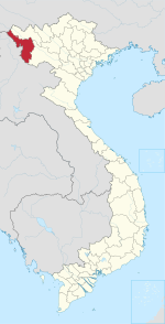
Map
Country Vietnam
ProvinceĐiện Biên
DistrictĐiện Biên
Time zoneUTC+07:00 (Indochina Time)

Na Ư is a commune () and village of the Điện Biên District of Điện Biên Province, northwestern Vietnam. It is located 24 kilometres from the border with Laos.

21°11′58″N 102°56′04″E / 21.19944°N 102.93444°E / 21.19944; 102.93444