Nassau station
Nassau | |||
|---|---|---|---|
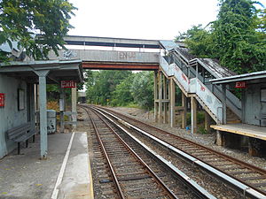
 Nassau station from the St. George-bound platform in July 2014. | |||
| Station statistics | |||
| Address | Saint Andrews Place & Bethel Avenue Staten Island, NY 10307 | ||
| Borough | Staten Island | ||
| Locale | Tottenville, Charleston | ||
| Coordinates | 40°31′04″N 74°14′18″W / 40.5178°N 74.2384°W | ||
| Division | [1] | ||
| Services | SIR Main Line | ||
| Transit | |||
| Structure | At-grade | ||
| Platforms | 2 side platforms | ||
| Tracks | 2 | ||
| Other information | |||
| Opened | after 1922[2]' | ||
| Closed | January 2017[3] (projected) | ||
| Traffic | |||
| 2023 | [4] | ||
| Rank | out of 423[4] | ||
| |||
| |||
Nassau is a Staten Island Railway station located roughly between the neighborhoods of Tottenville (to the south) and Charleston (to the north), in Staten Island, New York.
History

The station opened in 1921, over sixty years after the opening of the 1860 opening of the Staten Island Railway from Annadale to Tottenville.[2] The station was named for the nearby Nassau Smelting & Refining Company,[5] which extended the station to its current length in the 1970s.[6] The factory opened in 1882 as the Tottenville Copper Works and changed its name in 1931 to the Nassau Smelting & Refining Company. As a subsidiary of Bell Telephone System's Western Electric division, the factory recycled obsolete telephone equipment and manufactured copper wire and solder. It would later be called AT&T Nassau Metals. For more than 20 years the site was a vacant brownfield, until 2007, when the land was cleaned up and is now environmentally safe for future development.[7][8]
The station extension was built on timber covered with asphalt. Nassau, along with the nearby Atlantic station (also built next to a factory) were not modernized in the 1990s along with the rest of the line, because of the proposed station at Arthur Kill Road which was set to replace both stations. Due to structural deterioration of the extension and lack of maintenance, on September 2, 2010 most of the station towards the eastern end was closed off.[6][9] Construction on the replacement station, now simply called Arthur Kill, began in October 2013 and is set to open in January 2017.[3][6][5] With the opening of Arthur Kill, this station will be demolished.[10]
Station layout
| M | - | Crossover between platforms |
| P Platforms |
Side platform, doors will open on the right for the last car only | |
| Southbound | ← Main toward Tottenville (Atlantic) (No service: Arthur Kill) | |
| Northbound | → Main toward St. George (Richmond Valley) → | |
| Side platform, doors will open on the right for the last car only | ||
In the St. George bound direction, the station is located at Bethel Avenue and Saint Andrews Place. In the Tottenville bound direction it is at the end of Nassau Place. This station contains two four-car length (300 foot)[6] side platforms, but three-fourths of each platform towards the station's east (railroad north) end is closed and walled-off. Much like the nearby Atlantic station, only the last car of a train serves the station.[6][11] An overpass and exits are located at the west (railroad south) end. The staircase to St. Andrews Place on the east side has no canopy.
An abandoned siding sits next to the southbound (geographically northern) platform, which used to serve the Nassau Smelting & Refining Company.[6][12]
References
- ^ "Glossary". Second Avenue Subway Supplemental Draft Environmental Impact Statement (SDEIS) (PDF). Vol. 1. Metropolitan Transportation Authority. March 4, 2003. pp. 1–2. Archived from the original (PDF) on February 26, 2021. Retrieved January 1, 2021.
- ^ a b The line to Tottenville was open by 1860 according to Irvin Leigh and Paul Matus (December 23, 2001). "SIRT The Essential History". p. 5. Retrieved 2009-03-03., however Nassau did not appear in a SIRT timetable from 1921 according to "Time-Table No. 8 October 16, 1921". Retrieved 2009-03-23. A map from 1922 also did not list the station according to "Staten Island Railway Office of Valuation Engineer" (PDF). Retrieved 2015-10-11. A system map from 1949 did list the Nassau station according to Calcagno, Michael. "SIRT Track Map". Retrieved 2009-03-24.
- ^ a b [1]
- ^ a b "Annual Subway Ridership (2018–2023)". Metropolitan Transportation Authority. 2023. Retrieved April 20, 2024.
- ^ a b Stein, Mark D. (September 27, 2012). "It's official: New Staten Island Railway access for Tottenville". SILive.com. Staten Island. New York: Staten Island Advance. Retrieved 28 July 2015.
- ^ a b c d e f "Partial Closure of the Staten Island Railway Nassau Station" (Press release). MTA New York City Transit. August 30, 2010. Retrieved January 4, 2015.
- ^ Nyback, Glenn (October 1, 2006). "Cleanup of former Nassau Smelting site to begin". Staten Island Advance. Archived from the original on 2007-03-16.
{{cite news}}: Unknown parameter|deadurl=ignored (|url-status=suggested) (help) - ^ Yates, Maura (June 2, 2010). "Railway marking 150 years". Staten Island, New York: Staten Island Advance. Archived from the original on 2010-06-19. Retrieved 30 October 2015.
{{cite web}}: Unknown parameter|deadurl=ignored (|url-status=suggested) (help) - ^ Yates, Maura (September 1, 2010). "Nassau S.I. Railway station platform gets shorter". Staten Island, New York: Staten Island Advance. Archived from the original on 2010-09-03. Retrieved 30 October 2015.
{{cite web}}: Unknown parameter|deadurl=ignored (|url-status=suggested) (help) - ^ "Capital Program Oversight Committee Meeting June 2016" (PDF). www.mta.info. Metropolitan Transportation Authority. June 17, 2016. Retrieved June 17, 2016.
- ^ "Service Changes: Nassau". mta.info. Metropolitan Transportation Authority. Retrieved 28 July 2015.
- ^ Zaffarano, Steve (May 8, 2015). "Vintage photos of the 1980s on Staten Island: assau Smelting circa 1984 for Memories in Sunday News". Staten Island Advance. Retrieved 30 October 2015.


