Norwell Village Area Historic District
Appearance
Norwell Village Area Historic District | |
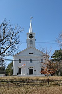
 First Parish Norwell | |
| Location | Norwell, Massachusetts |
|---|---|
| Coordinates | 42°9′41″N 70°47′28″W / 42.16139°N 70.79111°W |
| Architect | Multiple |
| Architectural style | Mid 19th Century Revival, Late 19th And 20th Century Revivals, Federal |
| NRHP reference No. | 82004432 [1] |
| Added to NRHP | June 2, 1982 |
The Norwell Village Area Historic District encompasses the village center of Norwell, Massachusetts. It is centered on the town common, first laid out in the 1640s, around which a number of public buildings are located, and radiates away along Main, Central, West, River, and Dover Streets. There are 34 buildings in the district, predominantly residential and representing a cross-section of architectural styles from the 18th to the early 20th centuries. Prominent buildings include the 1830 First Parish Church, the 1874 Italianate-style James Library building, and the 1934 Colonial Revival Cushing Memorial Town Hall.[2]
The district was added to the National Register of Historic Places in 1982.[1]
See also
References
- ^ a b "National Register Information System". National Register of Historic Places. National Park Service. April 15, 2008.
- ^ "NRHP nomination for Norwell Village Area Historic District". Commonwealth of Massachusetts. Retrieved 2014-05-26.


