Ochota
Appearance
Ochota | |
|---|---|
 Park in Ochota Szczęśliwice Housing Estate | |
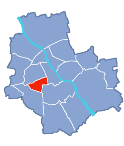
 Location of Ochota within Warsaw | |
| Country | |
| Voivodeship | Masovian |
| County/City | Warsaw |
| Government | |
| • Mayor | Maurycy Wojciech Komorowski |
| Area | |
| • Total | 9.7 km2 (3.7 sq mi) |
| Population (2003) | |
| • Total | 93,192 |
| • Density | 9,600/km2 (25,000/sq mi) |
| Time zone | UTC+1 (CET) |
| • Summer (DST) | UTC+2 (CEST) |
| Area code | +48 22 |
| Website | urzadochota.waw.p |
Ochota (Polish pronunciation: [ɔˈxɔta]) is a district of Warsaw, Poland, located in the central part of the Polish capital city's urban agglomeration.
The biggest housing estates of Ochota are:
- Kolonia Lubeckiego
- Kolonia Staszica
- Filtry
- Rakowiec
- Szosa Krakowska
- Szczęśliwice
- Osiedle Oaza
Neighbourhoods within the district
- Stara Ochota
- Filtry
- Rakowiec
- Szczęśliwice
See also
References
External links
52°12′59″N 20°58′52″E / 52.21639°N 20.98111°E

