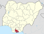
Opobo–Nkoro
Appearance
Opobo/Nkoro | |
|---|---|
| Coordinates: 4°34′5″N 7°33′10″E / 4.56806°N 7.55278°E | |
| Country | |
| State | Rivers State |
| Time zone | UTC+1 (WAT) |
Opobo/Nkoro is a Local Government Area in Rivers State, Nigeria. It is part of the Andoni/Opobo/nkoro constituency of the Nigerian National Assembly delegation from Rivers. The capital is Opobo Town.[1]
The Opobo/Nkoro people are mainly fishermen. The main language spoken by the Natives in Opobo is the Igbo language.
Pro-Natura International Nigeria has been assisting in community-led development in the LGA.[2]
References
- ^ "Opobo/Nkoro". AfDevInfo. Retrieved 2009-10-17.
- ^ "Opobo Nkoro Community Development Foundation Projects". Pro-Natura International Nigeria. Archived from the original on March 31, 2009. Retrieved 2009-10-17.
{{cite web}}: Unknown parameter|deadurl=ignored (|url-status=suggested) (help)
4°34′5″N 7°33′10″E / 4.56806°N 7.55278°E


