Ōtaki, New Zealand
This article needs additional citations for verification. (September 2016) |
Otaki | |
|---|---|
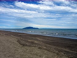
 Otaki Beach with Kapiti Island in the distance | |
| Coordinates: 40°45′S 175°9′E / 40.750°S 175.150°E | |
| Population (2013) | |
| • Total | 5,778 |
Otaki is a town in the Kapiti Coast District of the North Island of New Zealand, situated half way between the capital city Wellington, 70 kilometres to the southwest, and Palmerston North, 70 kilometres to the northeast. It is located on New Zealand State Highway 1 and the North Island Main Trunk railway between Wellington and Auckland and marks the northernmost point of the Wellington Region. The construction of the Kapiti Expressway and the Transmission Gully Motorway are currently underway and will cut traveling times to Wellington.[1]
In the 2013 census the town's population was 5,778, a slight increase since the 2006 census.[2]
The town is sited close to the banks of the Otaki River, 4 kilometres from its outflow into the Tasman Sea. There are recreational walks and cycling along the river and north of the mouth of the river is Otaki Beach. The safe sandy beach is popular as a swimming and fishing destination.
The surrounding district includes Te Horo and Manakau with its beach settlement at Waikawa Beach. The district is agricultural, with market gardens and lifestyle blocks. The economy of the town includes service industries for the rural community, outlet retail which is a destination for shoppers from Wellington and Palmerston North, and clean technology businesses with an emphasis on waste management. The local paper is the Otaki Mail.[3]
Otaki is home to Te Wānanga o Raukawa a Tikanga Māori university. It also hosts the annual Maoriland Film Festival and Otaki Kite Festival.[4]
Otaki Forks is the western gateway to the Tararua Forest Park. It offers recreational activities ranging from short walks, swimming, rafting and kayaking to advanced tramps of 3 – 5 days duration, including the Southern Crossing that ends at Kaitoke 45 km northeast of Wellington.
Since the early 19th century, the area has been home to Māori of the Ngati Raukawa iwi who had migrated from the Kāwhia area from about 1819, under the leadership of Te Rauparaha. They had supplanted the Rangitāne and Muaūpoko people.
At the request of Te Rauparaha, missionaries Henry Williams and Octavius Hadfield visited the area in December and Hadfield opened the first mission in the Wellington Region at Otaki.[5] At the nearby Raukawa marae is the Rangiātea Church, the original of which was completed in 1851. Burnt down in 1995, it was completely rebuilt by 2003.[6]
Inland from the township is the Otaki Racecourse, home of the Otaki Maori Racing Club since 1886.[7]
Notable people
- Iain Hewitson, Australian TV chef.
- Sir William Walkley, oil company executive
References
- ^ "Extra Wellington motorway lane and early finish for Kapiti Expressway on the cards". Stuff.co.nz. 2 January 2016. Retrieved 19 September 2016.
- ^ City Population: Otaki (Wellington)
- ^ About The Otaki Mail
- ^ Maoriland Film Festival
- ^ "The Exploration of New Zealand. Chapter III — Missionaries, Whalers, and Traders 1830–40". Victoria University.
- ^ Maclean, Chris (14 November 2012). "Wellington region - Māori buildings and marae". Te Ara - the Encyclopedia of New Zealand. Retrieved 19 January 2014.
- ^ Kapiti Coast District Council: Otaki

