
RMIT Building 11
| Spiritual Centre | |
|---|---|
RMIT Building 11 | |
 Spiritual Centre chapel and courtyard from the Franklin Street entrance | |
 | |
| General information | |
| Type | Education, worship |
| Architectural style | Italianate |
| Address | Franklin Street |
| Town or city | Melbourne, Victoria |
| Country | Australia |
| Completed | 1860 |
| Owner | RMIT |
| Design and construction | |
| Architect(s) | H.A. Williams, J.J. Clark and Gustav Joachimi |
| Architecture firm | Victorian Public Works Department |
| Renovating team | |
| Architect(s) | Khalid Bouden |
| Renovating firm | Desypher |
The Spiritual Centre of RMIT is a building located at the City campus of the Royal Melbourne Institute of Technology (RMIT University). The centre provides space for worship to all staff and students of RMIT, regardless of their faith and without showing favour to any one faith, and houses the RMIT Chaplaincy service.[1]
History
The building was built in 1860 as the chapel of the Old Melbourne Gaol. It was part of the "North Wing" of the gaol, and today is one of the few remaining buildings of the complex. It became part of RMIT after the gaol's decommissioning in 1929.[2] The other remaining buildings include: the main entrance gates, the female hospital, a service wing and a bathhouse (collectively known today, along with the chapel, as "RMIT Building 11"),[3] and the "East Block" (currently utilised as a museum). The "West Block" of the gaol was demolished to make way for an RMIT expansion, circa 1910,[2] and the large circular panopticon watchtower and male exercise yard were demolished in 1927 for the construction of the Emily McPherson College of Domestic Economy (now also part of RMIT).[4]
The centre is registered as a "notable building" by the Melbourne City Council, the Victorian Heritage Register and the National Trust of Australia.[3]
Gallery
-
 Main chapel of the RMIT Spiritual Centre
 -
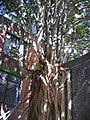 Banyan tree growing over a wall in a courtyard of the centre

See also
- Old Melbourne Gaol, to which the chapel was a former part of
- RMIT City, the campus of RMIT the Spiritual Centre is located
References
- ^ RMIT Chaplaincy - RMIT Spiritual Centre
- ^ a b Old Melbourne Gaol - Background and History
- ^ a b RMIT's Historical Buildings - Building 11
- ^ "Dig frees jail ghosts", Herald Sun, 29 September 2008; accessed 30 March 2009.
External links
37°48′29″S 144°57′55″E / 37.80806°S 144.96528°E