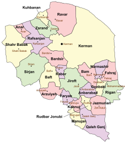
Rafsanjan County
Appearance
Rafsanjan County
شهرستان رفسنجان | |
|---|---|
 Location in Kerman Province | |
 Location of Kerman Province in Iran | |
| Coordinates: 30°30′N 55°40′E / 30.500°N 55.667°E | |
| Country | |
| Province | Kerman |
| Capital | Rafsanjan |
| Bakhsh (Districts) | Central District, Nuq District, Koshkuiyeh District, Ferdows District |
| Population (2006) | |
| • Total | 259,863 |
| Time zone | UTC+3:30 (IRST) |
| • Summer (DST) | UTC+4:30 (IRDT) |
| Rafsanjan County can be found at GEOnet Names Server, at this link, by opening the Advanced Search box, entering "9206670" in the "Unique Feature Id" form, and clicking on "Search Database". | |
Rafsanjan County (Persian: شهرستان رفسنجان) is a county in Kerman Province in Iran. The capital of the county is Rafsanjan. At the 2006 census, the county's population (including portions later split off to form Anar County) was 291,417, in 71,830 families; excluding those portions, the population was 259,863 in 64,027 families.[1] The county is subdivided into four districts (bakhsh): the Central District, Nuq District, Koshkuiyeh District, and Ferdows District. The county has five cities: Rafsanjan, Mes-e Sarcheshmeh, Bahreman, Koshkuiyeh, and Safayyeh. Former Iranian president, Akbar Hashemi Rafsanjani was born in Bahreman, in Rafsanjan County.[2]
References
- ^ "Census of the Islamic Republic of Iran, 1385 (2006)" (Excel). Statistical Center of Iran. Archived from the original on 2011-09-20.
- ^ "Iran Report: May 9, 2005". Radio Free Europe. 9 May 2005. Retrieved 31 May 2013.
- اطلس گیتاشناسی استانهای ایران [Atlas Gitashenasi Ostanhai Iran] (Gitashenasi Province Atlas of Iran)

