
Rakovets, Lviv Oblast
Rakovets
Раковець | |
|---|---|
 Flag | |
 Rakovets | |
| Coordinates: 49°39′11″N 24°01′20″E / 49.65306°N 24.02222°E | |
| Country | |
| Province | |
| District | Lviv Raion |
| Established | 1484 |
| Area | |
| • Total | 128 km2 (49 sq mi) |
| Elevation /(average value of) | 296 m (971 ft) |
| Population | |
| • Total | 207 |
| • Density | 1.6/km2 (4.2/sq mi) |
| Time zone | UTC+2 (EET) |
| • Summer (DST) | UTC+3 (EEST) |
| Postal code | 81164 |
| Area code | +380 3230 |
| Website | село Раковець, райцентр Пустомити, облцентр Львів (Ukrainian) |
Rakovets (Ukrainian: Ра́ковець, in the past had the name Mlynivtsi (Ukrainian: Млинівці)) – is a small village (selo), which is located in Lviv Raion, Lviv Oblast, of Western Ukraine. It belongs to Solonka rural hromada, one of the hromadas of Ukraine.[1] The village covers an area of 1,28 km2, and the population of the village is just about 207 persons.[2] Local government is administered by Rakovetska village council.[3]
Geography[edit]
The village is located at an altitude of 290 metres (950 ft) above sea level, on the right bank of the Zubra River, a left tributary of the Dniester River (Dniester river basin).[4] It is at a distance 1.5 kilometres (0.93 mi) on the east of the Highway M06 (Ukraine) (![]() M 06) at a distance 23 kilometres (14 mi) from the regional center of Lviv, 29 kilometres (18 mi) from the district center Pustomyty and 248 kilometres (154 mi) from the city of Uzhhorod.
M 06) at a distance 23 kilometres (14 mi) from the regional center of Lviv, 29 kilometres (18 mi) from the district center Pustomyty and 248 kilometres (154 mi) from the city of Uzhhorod.
History[edit]
Rakovets village was mentioned for the first time in 1484. Its name comes from the crayfish (Rak richkovyy). Originally the village was a town. Then, unable to compete with neighboring Lviv, over the years the city has become a village.
Until 18 July 2020, Rakovets belonged to Pustomyty Raion. The raion was abolished in July 2020 as part of the administrative reform of Ukraine, which reduced the number of raions of Lviv Oblast to seven. The area of Pustomyty Raion was merged into Lviv Raion.[5][6]
Cult constructions and attractions[edit]
The village has an architectural monument of national importance, the Roman Catholic Church of St. Valentine, which currently is inactive.[citation needed] This Catholic church was built in 1856. In 1890 it was severely damaged, but was later restored.[7]
An architectural monument of local importance in the village is the Church of the Holy Virgin Protection,[8] built in 1904 by the famous Ukrainian architect Vasyl Nahirnyy[9] and the bell tower of the church of the Holy Virgin Protection (wooden). The church belongs to the Diocese of UGCC.
The miraculous spring is at the eastern edge of Rakovets. The spring is very well groomed[10] and refers to the natural monuments.
Gallery[edit]
-
 Rakovets. Church of St.Valentine (1856). Is an inactive object.
 -
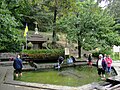 The miraculous spring in the village Rakovets, Pustomyty Raion.
 -
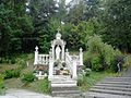 The stone chapel near the miraculous spring in the village Rakovets, Pustomyty Raion


References[edit]
- ^ "Солонковская громада" (in Russian). Портал об'єднаних громад України.
- ^ Село Раковець (Львівська обл.): карта вулиць (in Ukrainian)
- ^ Раковецька сільська рада (in Ukrainian)
- ^ Encyclopædia Britannica, Dniester River
- ^ "Про утворення та ліквідацію районів. Постанова Верховної Ради України № 807-ІХ". Голос України (in Ukrainian). 2020-07-18. Retrieved 2020-10-03.
- ^ "Нові райони: карти + склад" (in Ukrainian). Міністерство розвитку громад та територій України.
- ^ Костел св.Валентина (с.Раковець, Львівська обл.): карта, опис (in Ukrainian)
- ^ Церква Покрови Пресвятої Богородиці (с.Раковець, Львівська обл.): карта, опис (in Ukrainian)
- ^ uk:Нагірний Василь Степанович
- ^ Цілющі джерела України. Львівська область, Пустомитівський район, с. Раковець (in Ukrainian)
External links[edit]
- weather.in.ua, Rakovets' (Lviv region)
- Цілюще джерело / Ukraine / Lvivska / Pustomyty / (in Ukrainian)
Literature[edit]
- Історія міст і сіл УРСР : Львівська область, Пустомитівський район, Раковець. – К. : ГРУРЕ, 1968 р. Page 603 (in Ukrainian)
This article about a location in Lviv Oblast is a stub. You can help Wikipedia by expanding it. |