Rumaithiya
Appearance
Rumaithiya
الرميثية Rumaythiyah | |
|---|---|
City | |
| Coordinates: 29°19′N 48°4′E / 29.317°N 48.067°E | |
| Province | Hawalli Governorate |
| Government | |
| • Type | Municipality |
| Area | |
| • Metro | 4.7 km2 (1.8 sq mi) |
| Population | |
| • City | 58,957 |
| Time zone | GMT+3 |
Rumaithiya (Arabic: الرميثية Arabic:Ar-Rumaytheeyah Kuwaiti Arabic:Il-Irmeitheeyah ) is a residential area in Hawalli governorate, Kuwait, it's geographically divided into twelve blocks.
Blocks
Rumaithiya is officially divided into 12 blocks (قِطَع). Every block has a mosque and Rumaithiya Co-Op branch.
Landmarks
Masjids

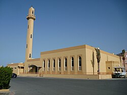
Rumaithiya was designed to make a space for a branch of the Co-op and the supermarket. Due to this, there are 12 government-built masjids in Rumaithiya, with one more government-built masjid near the main Co-op. The biggest masjid, Masjid Maqamis is in Block 11
Husayniyat
- Rumaithiya has the largest number of husayniyas in Kuwait with more than 70 Husayniya.
Rumaithiya Co-Op Society
Rumaithiya Co-Op Society is the official and only supermarket in the area.
- 12 Branches in every block
- 15,144+ Contributors
Sports area
This section is empty. You can help by adding to it. (April 2013) |
Public park
- Large public park in block 6
- Normal public park in block 8 with grass stadium
Schools
- 13 schools (the largest number in Kuwait) excluding private schools and kindergartens
Religion
Most of Rumaithia's people are Shia Muslim.[1][2] Due to this fact, there are a lot of husainiyas in the area.
References
- ^ https://theses.ncl.ac.uk/dspace/bitstream/10443/730/1/Taqi10.pdf
- ^ شيعة الكويت.. بين المشاركة والتمايز المذهبي Arabic CNN - 13 April 2007 - Access Date 30 January 2015.
Wikimedia Commons has media related to Rumaithiya.

