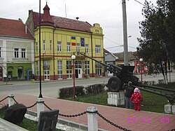
Seini
Appearance
47°44′52″N 23°17′7″E / 47.74778°N 23.28528°E
Seini | |
|---|---|
Town | |
 Town Hall | |
| Country | |
| County | Maramureș County |
| Status | Town |
| Government | |
| • Mayor | Gabriela Florica Tulbure (Social Democratic Party) |
| Area | |
| • Total | 58.91 km2 (22.75 sq mi) |
| Population (2011) | |
| • Total | 8,770 |
| Time zone | UTC+2 (EET) |
| • Summer (DST) | UTC+3 (EEST) |
| Climate | Cfb |
| Website | http://www.seini.ro/ |
Seini (German: Leuchtenburg; Hungarian: Szinérváralja) is a town in Maramureș County, northern Transylvania, Romania. It administers two villages, Săbișa (Kissebespatak) and Viile Apei (Apahegy).
| Year | Pop. | ±% |
|---|---|---|
| 1992 | 9,192 | — |
| 2002 | 9,439 | +2.7% |
| 2011 | 8,770 | −7.1% |
| Source: Census data | ||
Wikimedia Commons has media related to Seini.


