
Serralunga d'Alba
Serralunga d'Alba | |
|---|---|
| Comune di Serralunga d'Alba | |
 Coat of arms | |
Location of Serralunga d'Alba  | |
| Country | Italy |
| Region | Piedmont |
| Province | Cuneo (CN) |
| Area | |
| • Total | 8.44 km2 (3.26 sq mi) |
| Elevation | 414 m (1,358 ft) |
| Population (Dec. 2004)[2] | |
| • Total | 507 |
| • Density | 60/km2 (160/sq mi) |
| Demonym | Serralunghesi |
| Time zone | UTC+1 (CET) |
| • Summer (DST) | UTC+2 (CEST) |
| Postal code | 12050 |
| Dialing code | 0173 |
| Patron saint | St. Sebastian |
| Saint day | January 20 |
| Website | Official website |
Serralunga d'Alba is a comune (municipality) in the Province of Cuneo in the Italian region Piedmont, located about 60 kilometres (37 mi) southeast of Turin and about 45 kilometres (28 mi) northeast of Cuneo.
Serralunga d'Alba borders the following municipalities: Alba, Castiglione Falletto, Diano d'Alba, Monforte d'Alba, Montelupo Albese, Roddino, and Sinio.
Gallery
-
 Serralunga d’Alba and the Langhe.
 -
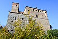 The Castle.


Demographic evolution

References
- ^ "Superficie di Comuni Province e Regioni italiane al 9 ottobre 2011". Italian National Institute of Statistics. Retrieved 16 March 2019.
- ^ All demographics and other statistics: Italian statistical institute Istat.