Shrigonda taluka
Appearance
Shrigonda Taluka taluka
श्रीगोंदा तालुका | |
|---|---|
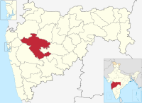
 Location of Shrigonda Taluka in Ahmednagar district in Maharashtra | |
| Country | |
| State | Maharashtra |
| District | Ahmednagar district |
| Headquarters | Shrigonda |
| Major villages | Kolgaon, Kashti, Belavandi, Mandavgan Katrabad |
| Government | |
| • Lok Sabha constituency | Ahmednagar (Lok Sabha constituency) |
| • Assembly constituency | Shrigonda |
| • MLA | Rahul Jagtap |
| Area | |
• Total | 1,605.61 km2 (619.93 sq mi) |
| Population (2001) | |
• Total | 277,319 |
| • Density | 170/km2 (450/sq mi) |
| Rain | 448.6 mm |
Shrigonda Taluka (Template:Lang-mr), is a taluka in Karjat subdivision of Ahmednagar District in Maharashtra State of India.[1] Its administrative headquarters is the town of Shrigonda.[2]
Area
The table below shows area of the taluka by land type.[3]
| Type of Land | Area (km2) | % of Total Area |
|---|---|---|
| Agriculture | 1385.16 | 86.27 |
| Forest | 152.1 | 9.47 |
| Other | 68.35 | 4.26 |
| Total | 1605.61 | 100 |
Villages
There are around 115 villages in Shrigonda taluka. For list of villages see Villages in Shrigonda taluka.
Population
The table below shows population of the taluka by sex. The data is as per 2001 census.[4]
| Population | % of Total Population | Number of Literate | Literacy (% of Population) | |
|---|---|---|---|---|
| Male | 143015 | 51.57 | 103101 | 72.09 |
| Female | 134304 | 48.43 | 73725 | 54.89 |
| Total | 277319 | 100 | 176826 | 63.76 |
Rain Fall
The Table below details of rainfall from year 1981 to 2004.[5]
| Year | Rainfall (mm) |
|---|---|
| 1981 | 614 |
| 1982 | 438 |
| 1983 | 521.6 |
| 1984 | 496 |
| 1985 | 359 |
| 1986 | 460 |
| 1987 | 497 |
| 1988 | 531 |
| 1989 | 610 |
| 1990 | 614 |
| 1991 | 438 |
| 1992 | 521.6 |
| 1993 | 496 |
| 1994 | 359 |
| 1995 | 460 |
| 1996 | 497 |
| 1997 | 531 |
| 1998 | 610 |
| 1999 | 571 |
| 2000 | 392 |
| 2001 | 352 |
| 2002 | 334 |
| 2003 | 87 |
| 2004 | 527 |
| 2005 | 484 |
| 2006 | 505 |
| 2007 | 675 |
| 2008 | 448 |
| 2009 | 499 |
| 2010 | 710 |
| 2011 | 326 |
See also
References
- ^ Talukas in Ahmednagar district. Ahmednagar.gov.in. Retrieved on 2011-12-23.
- ^ "Shrigonda". Ahmadnagar District. Archived from the original on 25 September 2012.
{{cite web}}: Unknown parameter|deadurl=ignored (|url-status=suggested) (help) - ^ Talukas geographic information. Ahmednagar.gov.in. Retrieved on 2011-12-23.
- ^ Talukas population information. Ahmednagar.gov.in. Retrieved on 2011-12-23.
- ^ Rainfall information of Ahemadnagar district. Ahmednagar.gov.in. Retrieved on 2011-12-23.

