Sierra Madre (Philippines)
| Sierra Madre Mountains (Philippines) | |
|---|---|
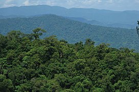
 View south of the northern Sierra Madre from the peak of Mount Cagua in Cagayan | |
| Geography | |
| Country | Philippines |
| Province | |
| Region | |
| Borders on | Pacific Ocean |
The Sierra Madre Mountains is the longest mountain range in the Philippines. Running in the north-south direction from the provinces of Cagayan to the north and Quezon to the south, the mountains form the eastern backbone of Luzon Island, the largest island of the archipelago. It is bordered by the Pacific Ocean to the east. The Pacific coast of Luzon along the Sierra Madre is less developed as the lofty and continuous mountains forms a bold and an almost inaccessible shore, exposed to the full force of the northeast monsoon and the waves of the Pacific Ocean.[1] Some of communities east of the mountain range and along the coast are so remote they are only accessible by plane or boat.
The Quezon Protected Landscape is situated at the southern part of the range.[2]
Geography
The Sierra Madre is the longest mountain range in the Philippines. In the north, the range starts in the province of Cagayan and ends in the south in the province of Quezon. In the province of Nueva Vizcaya, the Caraballo Mountains connect Sierra Madre Mountain range with the Cordillera Central range.
The mountain range serves as a typhoon barrier, attenuating incoming typhoons from the Pacific Ocean before reaching the central mainland.[3]
Remote communities
Some coastal communities east of the Sierra Madre Mountains, especially from Palanan, Isabela heading north to near the northernmost tip of mainland Cagayan, are remote and isolated with no roads connecting them to towns west of the mountain range. Towns like Palanan and Maconacon, Isabela can only be reached by plane from Cauayan City or a boat ride from Aurora province, south of Isabela.[4]
Highest elevation
The range's highest point is unclear, and several peaks are attributed as the highest. Mount Anacuao in Aurora province stands at 6,069 feet (1,850 m), while Mount Cetaceo in Cagayan is of similar altitude. However, an expedition in April 2012 to Mount Guiwan (Nueva Vizcaya) preliminarily measured an altitude of 6,283 feet (1,915 m) on the summit.[5]
Ecoregions


Ecoregions in the range are in the tropical and subtropical moist broadleaf forests (lower) and tropical and subtropical coniferous forests (higher) biomes.
National parks
Other protected areas
- Amro River Protected Landscape
- Casecnan Protected Landscape
- Dinadiawan River Protected Landscape
- La Mesa Watershed Reservation
- Magapit Protected Landscape
- Northern Sierra Madre Natural Park
- Peñablanca Protected Landscape and Seascape
- Quezon Protected Landscape
- Quirino Protected Landscape
- Simbahan-Talagas Protected Landscape
- Talaytay Protected Landscape
- Upper Marikina River Basin Protected Landscape
Active volcanoes
- Cagua Volcano an active volcano in Cagayan province that last erupted in 1907
Endemic species
In the forest, in April 2010, the endemic lizard species Northern Sierra Madre Forest monitor lizard - Varanus bitatawa (common name: Butikaw) was described to science, although the Aeta and Ilongot indigenous peoples have known and used it as a food source.
Human activities

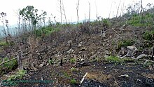
The Sierra Madre mountain range forest habitat is threatened by human activities. Settlers living at the lower portions of the slopes generally are supported by work in logging and charcoal-making. Some portions of the forest cover are already second growth forest.
See also
References
- ^ U.S. Coast and Geodetic Survey (1919). "United States Coast Pilot Philippine Islands Part 1", pg. 44. Government Printing Office, Washington.
- ^ Coursey, Oscar William (1903). History and Geography of the Philippine Islands. Educator School Supply Company.
- ^ Bordadora, Norman (12 November 2006). "Sierra Madre blocks 'Queenie' punch". Philippine Daily Inquirer . Retrieved 25 December 2014.
- ^ Christian (2011-06-13). "Palanan and Maconacon". Off the Beaten Track in the Philippines. Retrieved on 2014-09-28.
- ^ Gray, Shirley (1 March 2003). The Philippines - True books. CT: Children's Press. ISBN 0516242121.
External links
- Sierra Madre (Philippines)
- Mountain ranges of the Philippines
- Luzon
- Landforms of Aurora (province)
- Landforms of Cagayan
- Landforms of Isabela (province)
- Landforms of Quirino
- Landforms of Nueva Ecija
- Landforms of Bulacan
- Landforms of Rizal
- Landforms of Metro Manila
- Landforms of Laguna (province)
- Landforms of Quezon


