Skikda
Skikda
سكيكدة | |
|---|---|
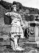
 downtown Skikda | |
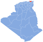
 Location of Skikda in the Skikda Province | |
| Coordinates: 36°52′N 6°54′E / 36.867°N 6.900°E | |
| Country | |
| Province | Skikda |
| District | Skikda District |
| Founded | 1838 |
| Area | |
| • Total | 52 km2 (20 sq mi) |
| Elevation | 18 m (59 ft) |
| Population (2008 census) | |
| • Total | 182,903 |
| • Density | 3,500/km2 (9,100/sq mi) |
| Time zone | UTC+1 (CET) |
| Postal code | 21000 |
| Climate | Csa |
Skikda (Template:Lang-ar) is a city in north eastern Algeria and a port on the Gulf of Stora, the ancient Sinus Numidicus. It is the capital of Skikda Province and Skikda District.
History

The modern city of Skikda was founded in 1838 by the French under the name Philippeville. It was located on the ruins of an ancient Phoenician city which later flourished as a large Roman city called Rusicade, a Punic word which means "Promontory of fire". Rusicade contained the largest Roman theatre in Algeria, dating from the reign of the Emperor Hadrian. In the 5th century, the Roman port was destroyed by the Vandals.
The modern city was founded by Sylvain Charles Valée, for the French to use as a port for Constantine, the third largest city in Algeria. The Constantine-Philippeville railway line was subsequently developed. On October 10, 1883, there was an earthquake in Philippeville.[1]
Towards the end of World War II, a UNRRA refugee camp was established near the city; known as Camp Jeanne d'Arc. On January 25, 1945, 200 Jews holding citizenship from countries in North and South America were sent from the Bergen-Belsen concentration camp to Switzerland as part of a prisoner exchange group. They were later sent to the UNRRA camp in Skikda.[2]
Battle of Philippeville
An attack by the FLN in 1955 during the war of Independence left around 123 civilians dead, mainly French and those suspected of collaboration.[3] Angered over the massacre of civilians, including women, seniors, and babies, the French escalated their offensive against the FLN. Reprisals by French forces may have killed between 1,200 (according to French sources,) and 12,000 (according to the FLN.)
1989 shipping disaster
The city has a commercial harbour with a gas and oil terminal. On 15 February 1989 the Dutch tanker the MV Maassluis was anchored just outside the port, waiting to dock the next day at the terminal, when extreme weather broke out. The ship's anchors did not hold and the ship smashed on the pier-head of the port. The disaster killed 27 of the 29 people on board.[4]
Modern Skikda
The city has a population of 250,000. Natural gas, oil refining, and petrochemical industries were developed in the 1970s and pipelines have been built for their transportation. The city hall (a neo-moorish style palace) and the railroad station were designed by Le Corbusier.
The official city flag colours are blue and white, the colours of the Mediterranean. The current postal code is 21000. Skikda has the third largest commercial port in Algeria after Algiers and Oran. It has also a petrochemical terminal port and a smaller fishing port in Stora, and there are many beaches along the natural Mediterranean coastline. There is also a closed airport near the petrochemical complex.
Geography

Skikda lies on the coast of the Gulf of Stora, part of the Mediterranean Sea. The landscape is hilly and forested, with high ridges on both the western and eastern sides of the city.
Climate
Skikda has a Mediterranean climate (Köppen climate classification Csa), with cool, wet winters and very warm, dry summers.
| Climate data for Skikda (1961–1990, extremes 1926–1992) | |||||||||||||
|---|---|---|---|---|---|---|---|---|---|---|---|---|---|
| Month | Jan | Feb | Mar | Apr | May | Jun | Jul | Aug | Sep | Oct | Nov | Dec | Year |
| Record high °C (°F) | 26.4 (79.5) |
30.6 (87.1) |
32.0 (89.6) |
34.6 (94.3) |
38.8 (101.8) |
41.0 (105.8) |
44.4 (111.9) |
46.7 (116.1) |
44.0 (111.2) |
38.0 (100.4) |
33.0 (91.4) |
28.0 (82.4) |
46.7 (116.1) |
| Mean daily maximum °C (°F) | 16.1 (61.0) |
16.6 (61.9) |
17.5 (63.5) |
19.5 (67.1) |
22.2 (72.0) |
25.1 (77.2) |
28.4 (83.1) |
28.9 (84.0) |
27.3 (81.1) |
24.3 (75.7) |
20.5 (68.9) |
17.1 (62.8) |
22.0 (71.6) |
| Daily mean °C (°F) | 12.0 (53.6) |
12.3 (54.1) |
13.2 (55.8) |
15.1 (59.2) |
17.9 (64.2) |
21.0 (69.8) |
23.9 (75.0) |
24.6 (76.3) |
22.9 (73.2) |
19.8 (67.6) |
16.1 (61.0) |
13.0 (55.4) |
17.6 (63.7) |
| Mean daily minimum °C (°F) | 8.0 (46.4) |
7.9 (46.2) |
8.8 (47.8) |
10.7 (51.3) |
13.5 (56.3) |
16.7 (62.1) |
19.4 (66.9) |
20.2 (68.4) |
18.5 (65.3) |
15.3 (59.5) |
11.6 (52.9) |
8.9 (48.0) |
13.3 (55.9) |
| Record low °C (°F) | 0.0 (32.0) |
−0.5 (31.1) |
−0.6 (30.9) |
3.0 (37.4) |
5.0 (41.0) |
8.0 (46.4) |
10.2 (50.4) |
12.3 (54.1) |
11.6 (52.9) |
2.0 (35.6) |
0.0 (32.0) |
0.0 (32.0) |
−0.6 (30.9) |
| Average precipitation mm (inches) | 115.3 (4.54) |
94.0 (3.70) |
75.6 (2.98) |
60.8 (2.39) |
29.9 (1.18) |
13.1 (0.52) |
2.9 (0.11) |
9.7 (0.38) |
30.1 (1.19) |
75.0 (2.95) |
99.2 (3.91) |
123.0 (4.84) |
728.8 (28.69) |
| Average precipitation days (≥ 0.1 mm) | 15 | 11 | 12 | 10 | 7 | 5 | 1 | 3 | 7 | 12 | 13 | 16 | 112 |
| Average relative humidity (%) | 75 | 75 | 75 | 75 | 76 | 75 | 73 | 75 | 75 | 74 | 75 | 75 | 75 |
| Mean monthly sunshine hours | 139.5 | 155.4 | 207.7 | 222.0 | 279.0 | 306.0 | 356.5 | 322.4 | 258.0 | 201.5 | 156.0 | 133.3 | 2,737.3 |
| Mean daily sunshine hours | 4.5 | 5.5 | 6.7 | 7.4 | 9.0 | 10.2 | 11.5 | 10.4 | 8.6 | 6.5 | 5.2 | 4.3 | 7.5 |
| Source 1: NOAA[5] | |||||||||||||
| Source 2: Deutscher Wetterdienst (extremes 1926–1992, sun 1952–1990, humidity 1973–1992, and avg. precipitation days 1952–1970)[6] | |||||||||||||
Economy
Historically, Skikda is known for its seaport. It was described, in 1911, by Baedeker as having "the youngest Algerian seaport."[7]
On the 19th January 2004, a fire and explosion at the Skikda LNG facility killed 29 people and caused $940,000,000 worth of damage. The accident incapacitated three LNG trains and impacted approximately 2% of the world’s liquefaction capacity. The explosion was preceded by the ingestion of a sizable leak of cold hydrocarbon into the boiler of the westernmost LNG line. This caused the boiler to explode. According to the 2014 Marsh report into the worlds largest industrial disaster, the Skikda explosion is ranked #3 in the hydrocarbon industry.
Transportation

The main road from Skikda is the N3 to El Arrouch, Constantine, Batna, Biskra and Touggourt. Smaller local roads lead to the towns of Stora (to the northwest along the coast), Beni Bechir (to the south), Bissy and Azzabe (to the southeast), and El Mersa and Chetaibi (to the east).
Skikda is the terminus of the Constantine-Skikda railway line. The city is served by Skikda Airport, although this airport is currently unused.
References
- ^ "EARTHQUAKE SHOCK IN ALGERIA". New York Times. 1883-10-10.
- ^ source Page at Holocaust database
- ^ Ben Abro, Assassination! July 14, University of Nebraska Press (2001), p251
- ^ Website Nieuwsdossier on Sinking of Maassluis, retrieved 3 August 2010
- ^ "Climate Normals for Skikda". National Oceanic and Atmospheric Administration. Retrieved 27 March 2016.
- ^ "Klimatafel von Skikda (Philippeville) / Algerien" (PDF). Baseline climate means (1961-1990) from stations all over the world (in German). Deutscher Wetterdienst. Retrieved 27 March 2016.
- ^ "Philippeville, Algeria". World Digital Library. 1899. Retrieved 2013-09-26.


