South Greenland
| South Greenland syd-Grønland | |||||||
|---|---|---|---|---|---|---|---|
| Colony of Denmark–Norway (1728?-1814) Colony of Denmark (1814-1950) | |||||||
| 1728?-1950 | |||||||
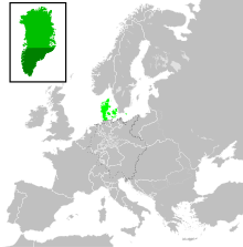
 South Greenland in Dark Green. North Greenland in Light Green. Mainland Denmark in Lime Green. | |||||||
| Government | |||||||
| • Type | Monarchy | ||||||
| Monarch | |||||||
• 1728-1730 | Frederick IV first | ||||||
• 1947-1950 | Frederick IX last | ||||||
| Governor/Royal inspectors | |||||||
• 1782–1789 | Bendt Olrik first | ||||||
• 1945–1950 | Carl Fredrik Simony last | ||||||
| History | |||||||
• Established | 1728? | ||||||
• Disestablished | 1950 | ||||||
| |||||||
| Today part of | |||||||
South Greenland was a Danish colony on Greenland consisting of the trading centers and missionary stations along the southwest coast of the island. Its capital was at Godthaab (modern Nuuk).[1] The northernmost town of South Greenland was Holsteinborg, which bordered Egedesminde, which was the southernmost town of North Greenland. This boundary between South and North Greenland ran at around 68°N degree of latitude, and in the South, South Greenland stretched to 59°30'N,[2] or to the southernmost point of Greenland.
In 1911, as the administration of the colony was removed from the Royal Greenland Trading Department and folded into the Danish Ministry of the Interior, a provincial council (Template:Lang-da) was established. It was elected indirectly from the local councils and had little say in the management of the colony.
It was united with North Greenland in 1950.[verification needed]
See also
- List of inspectors of South Greenland, for the chief officers of the colony between 1782 and 1924
- List of governors of South Greenland, for the chief officers of the colony between 1924 and 1950
- North Greenland
References
- ^ Brewster, David. "Greenland". The Edinburgh Encyclopedia, Vol 10. J. & E. Parker, 1832.
- ^ James Bell: A System of Geography. Glasgow 1892 p. 281 CHAP. III-GREENLAND.

