
Stara Sil
Stara Sil
Стара Сіль | |
|---|---|
 Flag  Coat of arms | |
 Stara Sil | |
| Coordinates: 49°29′22″N 22°57′56″E / 49.48944°N 22.96556°E | |
| Country | |
| Oblast | Lviv Oblast |
| Raion | Sambir Raion |
| Hromada | Staryi Sambir urban hromada |
| Established | 1421 |
| Area | |
• Total | 193 km2 (75 sq mi) |
| Elevation /(average value of) | 346 m (1,135 ft) |
| Population (2022) | |
• Total | 1,074 |
| • Density | 5.6/km2 (14/sq mi) |
| Time zone | UTC+2 (EET) |
| • Summer (DST) | UTC+3 (EEST) |
| Postal code | 82066 |
| Area code | +380 3238 |
| Website | смт Стара Сіль (Ukrainian) |
Stara Sil (Ukrainian: Стара Сіль, lit. 'Old Salt'; Polish: Stara Sól; German: Salzbrock), formerly known as Stara Ropa (Ukrainian: Стара Ропа, lit. 'Old Brine') is a rural settlement in Sambir Raion, Lviv Oblast, of Western Ukraine. It belongs to Staryi Sambir urban hromada, one of the hromadas of Ukraine.[1] Population: 1,074 (2022 estimate)[2].
Geography
[edit]The settlement is located in the Ukrainian Carpathians hills in the western part of the Lviv region. This is on the path Staryi Sambir – Khyriv at a distance of 7 kilometres (4.3 mi) from the district center Staryi Sambir and 96 kilometres (60 mi) from the regional center of Lviv.
History and attractions
[edit]The first historical mention is traditionally considered the year 1254. However, according to some sources, the settlement was founded as an outpost in the 9–10 century.[3] Since ancient times in the territory settlement were the extraction of salt, hence the name of the settlement.
Stara Sil was granted the Magdeburg Law in 1421.
Until 18 July 2020, Stara Sil belonged to Staryi Sambir Raion. The raion was abolished in July 2020 as part of the administrative reform of Ukraine, which reduced the number of raions of Lviv Oblast to seven. The area of Staryi Sambir Raion was merged into Sambir Raion.[4][5]
Until 26 January 2024, Stara Sil was designated urban-type settlement. On this day, a new law entered into force which abolished this status, and Stara Sil became a rural settlement.[6]
Stara Sil contains a number of listed architectural monuments of Sambir Raion:
- Church of the Resurrection of Christ (wooden), 17th century
- The bell tower of the church of the Resurrection of Christ (wooden), 17th century
- Church of St. Michael (stone), 1613–1660, 1922–1928
- The bell tower of the church of St. Michael (mix.), 17th century
- Church of Saint Paraskevi (wooden), 16th–17th centuries
- The bell tower of the church of St. Paraskevi, 17th century
Notable people
[edit]Ludwik Dutkiewicz (1921–2008), an artist, was born in Stara Sil.[7]
Gallery
[edit]-
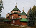
 St. Archangel Michael catholic church
 -
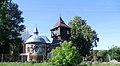 Church and bell tower of the St. Archangel Michael catholic church
 -
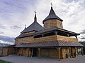 Church of St. Paraskevi
 -
 Church of the Resurrection
._%D0%A1%D1%82%D0%B0%D1%80%D0%B0_%D0%A1%D1%96%D0%BB%D1%8C..JPG)
._%D0%A1%D1%82%D0%B0%D1%80%D0%B0_%D0%A1%D1%96%D0%BB%D1%8C..JPG)


References
[edit]- ^ "Старосамборская городская громада" (in Russian). Портал об'єднаних громад України.
- ^ Чисельність наявного населення України на 1 січня 2022 [Number of Present Population of Ukraine, as of January 1, 2022] (PDF) (in Ukrainian and English). Kyiv: State Statistics Service of Ukraine. Archived (PDF) from the original on 4 July 2022.
- ^ Мандри Україною. Стара Сіль. (in Ukrainian)
- ^ "Про утворення та ліквідацію районів. Постанова Верховної Ради України № 807-ІХ". Голос України (in Ukrainian). 2020-07-18. Retrieved 2020-10-03.
- ^ "Нові райони: карти + склад" (in Ukrainian). Міністерство розвитку громад та територій України.
- ^ "Что изменится в Украине с 1 января". glavnoe.in.ua (in Russian). 1 January 2024.
- ^ "Ludwik Dutkiewicz b. 2 February 1921". daao.org.au. Design & Art Australia Online. Retrieved 22 April 2022.
External links
[edit]- смт. Стара Сіль, Львівська область, Старосамбірський район, Облікова картка (in Ukrainian)
- Стара Сіль, церква Воскресіння Господнього XVII ст., церква Св. Параскеви XVII ст. (in Ukrainian)
- Via Est Vita. Стара Сіль. Частина 1 Костел Архістратига Михаїла (in Ukrainian)
- weather.in.ua Stara Sil'
Literature
[edit]- Історія міст і сіл УРСР : Львівська область, Населені пункти, центри селищних і сільських Рад, Старосамбірського району, Стара Сіль. – К. : ГРУРЕ, 1968 р. Page 785 (in Ukrainian)