Jump to content

Subdivisions of Sudan

From Wikipedia, the free encyclopedia

This is an old revision of this page, as edited by Cydebot (talk | contribs) at 21:11, 28 October 2017 (Robot - Speedily moving category Country subdivisions of Africa to Category:Country subdivisions in Africa per CFDS.). The present address (URL) is a permanent link to this revision, which may differ significantly from the current revision.

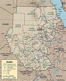
Political map of Sudan. Hala'ib Triangle has been under Egyptian administration since 2000.

Sudan is divided into fifteen states (wilayat, sing. wilayah) which in turn are subdivided into 86 districts. Before the secession of South Sudan on July 9, 2011, Sudan was the largest country in Africa and had 25 states.