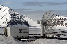
Svalbard Rocket Range
The Svalbard Rocket Range (Template:Lang-no) or SvalRak is a launch site for sounding rockets at Ny-Ålesund in Svalbard, Norway. The site has been in use since 1997 and is owned by Andøya Rocket Range, which is again owned by the Norwegian Space Centre and the Kongsberg Group. SvalRak's location at the 79th parallel north makes it well-suited for launching rockets to investigate Earth's magnetic field. It is used mostly by American, Japanese and Norwegian researchers. It is the world's northernmost launch site.
History

Planning of a launch site in Ny-Ålesund started in 1993,[1] a location chosen because of its ideal location to study the polar cusp.[2] Construction of the site started in the summer of 1997.[3] The Norwegian Institute for Air Research, which conducts air measurements in Ny-Ålesund, was concerned that the rockets could pollute their measurements.[4] A test rocket was launched on 15 November.[5] The first proper launch was a Norwegian rocket, Isbjørn 1, which contained instruments from University Centre in Svalbard, the University of Tromsø and the Norwegian Defence Research Establishment.[3] The 510-kilogram (1,120 lb) rocket had a payload of 70 kilograms (150 lb) and reached 120 kilometers (75 mi) altitude.[5] It was followed by two Black Brant rockets for the National Aeronautics and Space Administration which reached an altitude of 500 kilometers (310 mi).[6]
SvalRak originally held permission to fire four rockets every four years.[3] Forty-one rockets had been launched by 2004, with a peak altitude of 1,108 kilometers (688 mi).[7] The site was upgraded in 2008.[2]
Use
SvalRak is the world's northern-most rocket launch site, and is located at the 79th parallel north.[5] This makes it an ideal location for sending instruments into Earth's magnetic field and the polar cups, cleft and cup.[2] It is also used for studying the Magnetopause and aurora borealis, for which Ny-Ålesund is the most convenient location because of its ease of access.[3] It is owned by Andøya Rocket Range, which is owned by the Norwegian Space Center (90 percent) and the Kongsberg Group (10 percent). SvalRak has no permanent staff in Ny-Ålesund.[2] The main users are American and Japanese and to a less extent Norwegian.[8]
References
- ^ Rødberg, Ole Anders; Collett, John Petter (October 2004). "Norwegian Space Activities 1958–2003: A Historical Overview". European Space Agency. p. 48. Archived from the original (PDF) on 10 April 2012. Retrieved 10 April 2012.
- ^ a b c d "Other Research Institutions in Ny-Ålesund". Kings Bay. May 1997. Retrieved 30 October 2012.
- ^ a b c d "SvalRak: Sounding Rocket Launch Facility in Ny-Ålesund". Ny-Ålesund Science Managers Committee. May 1997. Archived from the original on 30 October 2012. Retrieved 30 October 2012.
{{cite web}}: Unknown parameter|deadurl=ignored (|url-status=suggested) (help) - ^ Sellevåg, Inge (15 November 1997). "–Spent på Svalbardrakettene". Bergens Tidende (in Norwegian). p. 34.
- ^ a b c Larsen, Rolf L. (16 November 1997). "Romfartshistorie på 79° nord". Aftenposten (in Norwegian).
- ^ Sellevåg, Inge (15 November 1997). "–Svar ikke nødvendig". Bergens Tidende (in Norwegian). p. 34.
- ^ "SvalRak". Astronautix. Retrieved 30 October 2012.
- ^ "St.meld. nr. 22 (2008-2009) Svalbard" (in Norwegian). 17 April 2009. Retrieved 30 October 2012.

