Svratka (river)
Appearance
| Svratka | |
|---|---|
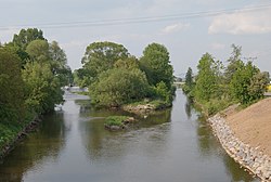
 Confluence of Svratka (left) and Svitava rivers | |
 | |
| Location | |
| Country | Czech Republic |
| Physical characteristics | |
| Source | |
| • location | Bohemian-Moravian Highlands |
| Mouth | |
• location | Dyje River |
• coordinates | 48°54′16″N 16°36′44″E / 48.90444°N 16.61222°E |
| Length | 168.5 km (104.7 mi) |
| Basin size | 7,115.60 km2 (2,747.35 sq mi) |
| Discharge | |
| • average | 27 m3/s (950 cu ft/s) near estuary |
| Basin features | |
| Progression | Thaya→ Morava→ Danube→ Black Sea |
The Svratka (Czech pronunciation: [ˈsvratka]), formerly Švarcava (Template:Lang-de) is a river in the South Moravian Region of the Czech Republic. It is 168 kilometres (104 mi) long, and its basin area is 7,116 square kilometres (2,748 sq mi).[1] It rises in the Bohemian-Moravian Highlands, converges with the Svitava in Brno, and flows into the Dyje (Thaya) a near Mikulov. The river is known in the local Moravian dialect as the Švarcava (from the German name of the river Schwarzach).

References
Wikimedia Commons has media related to Svratka River.
- ^ "Charakteristiky toků a povodí ČR - Svratka" (in Czech). VÚV TGM. Retrieved 2018-05-08.
