
TIROS-N
| File:First TIROS-N satellite.jpg | |||||||||||||||||||||||||||||
| Mission type | weather | ||||||||||||||||||||||||||||
|---|---|---|---|---|---|---|---|---|---|---|---|---|---|---|---|---|---|---|---|---|---|---|---|---|---|---|---|---|---|
| Operator | NOAA | ||||||||||||||||||||||||||||
| COSPAR ID | 1978-096A | ||||||||||||||||||||||||||||
| SATCAT no. | 11060 | ||||||||||||||||||||||||||||
| Spacecraft properties | |||||||||||||||||||||||||||||
| Launch mass | 734 kilograms (1,618 lb) | ||||||||||||||||||||||||||||
| Start of mission | |||||||||||||||||||||||||||||
| Launch date | 11:23, October 13, 1978[1] | ||||||||||||||||||||||||||||
| Rocket | Atlas F[1] | ||||||||||||||||||||||||||||
| Launch site | Vendenberg AFB | ||||||||||||||||||||||||||||
| Orbital parameters | |||||||||||||||||||||||||||||
| Reference system | Geocentric | ||||||||||||||||||||||||||||
| Perigee altitude | 829 kilometres (515 mi) | ||||||||||||||||||||||||||||
| Apogee altitude | 845 kilometres (525 mi) | ||||||||||||||||||||||||||||
| Inclination | 98.70° | ||||||||||||||||||||||||||||
| Period | 101.70 min | ||||||||||||||||||||||||||||
| |||||||||||||||||||||||||||||
TIROS-N satellite is the first of the TIROS-N series. It is a weather satellite launched in October 13, 1978.[2] It was designed to become operational in 2 years. Its mass is 734 kilograms.[2] Its perigee to Earth is 829 kilometers. Its apogee is 845 kilometers away from Earth. Its inclination is 98.70 degrees. It was managed by the US National Oceanic and Atmospheric Administration (NOAA); designed and launched by NASA. The spacecraft was 3-axis stabilized.[2] TIROS-N was operated for 868 days until deactivated by NOAA on February 27, 1981.[3]
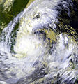
Gallery of cyclones captured by this satellite
-
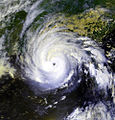
 Typhoon Tip 2 days after reaching peak intensity.
 -
-

-
-
-
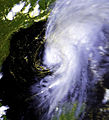
 Hurricane Gloria


References
- ^ a b "NSSDCA-Master Catalog-TIROS-N". nssdca.gsfc.nasa.gov. NASA. Retrieved 25 August 2016.
- ^ a b c "Tiros N". Retrieved 10 May 2014.
- ^ "TIROS-N/NOAA Program -- 1978-1986". NASA. Retrieved 10 May 2014.
External links
TIROS satellites | ||
|---|---|---|
| TIROS |  | |
| TOS | ||
| ITOS | ||
| TIROS-N | ||
| Adv. TIROS-N | ||
Template:Space-based meteorological observation
This spacecraft or satellite related article is a stub. You can help Wikipedia by expanding it. |