Tamaree, Queensland
| Tamaree Gympie, Queensland | |||||||||||||||
|---|---|---|---|---|---|---|---|---|---|---|---|---|---|---|---|
| Coordinates | 26°08′10″S 152°39′50″E / 26.1361°S 152.6638°E | ||||||||||||||
| Population | 1,000 (2021 census)[1] | ||||||||||||||
| • Density | 120/km2 (300/sq mi) | ||||||||||||||
| Postcode(s) | 4570 | ||||||||||||||
| Area | 8.6 km2 (3.3 sq mi) | ||||||||||||||
| Time zone | AEST (UTC+10:00) | ||||||||||||||
| Location | |||||||||||||||
| LGA(s) | Gympie Region | ||||||||||||||
| State electorate(s) | Gympie | ||||||||||||||
| Federal division(s) | Wide Bay | ||||||||||||||
| |||||||||||||||
Tamaree is a rural residential locality in the Gympie Region, Queensland, Australia.[2] In the 2021 census, Tamaree had a population of 1,000 people.[1]
Geography
[edit]Tamaree is located 7 kilometres (4 mi) north of Gympie's central business district.
The locality is bounded to the west by Old Maryborough Road.[3]
The North Coast railway line enters the locality from the south-west (Banks Pocket) and exits to the north (Corella). The locality is served by the Tamaree railway station (26°07′51″S 152°39′54″E / 26.1308°S 152.6651°E).[4]
The land use is rural residential.[3]
History
[edit]

Tamaree Provisional School opened on 12 July 1904. On 1 January 1909 it became Tamaree State School. It closed on 31 March 1965.[5]
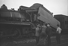
On Saturday 18 October 1947 at Tamaree railway station, the north-bound Townsville mail train crashed head-on into the stationary south-bound train from Rockhampton, with both trains carrying hundreds of passengers. Two crew in the south-bound train were killed along with six passengers in the north-bound train.[6][7]
Demographics
[edit]At the 2011 census, Tamaree had a population of 664.[8]
In the 2016 census, Tamaree had a population of 880 people.[9]
In the 2021 census, Tamaree had a population of 1,000 people.[1]
Education
[edit]There are no schools in Tamaree. The nearest government primary schools are Chatsworth State School in neighbouring Chatsworth to the west, Two Mile State School in Two Mile to the south-east, and Gympie West State School in Gympie to the south. The nearest government secondary school is James Nash State High School in Gympie to the south.[3]
References
[edit]- ^ a b c Australian Bureau of Statistics (28 June 2022). "Tamaree (SAL)". 2021 Census QuickStats. Retrieved 28 February 2023.
- ^ "Tamaree – locality in Gympie Region (entry 48136)". Queensland Place Names. Queensland Government. Retrieved 27 December 2020.
- ^ a b c "Queensland Globe". State of Queensland. Retrieved 15 March 2021.
- ^ "Railway stations and sidings - Queensland". Queensland Open Data. Queensland Government. 2 October 2020. Archived from the original on 5 October 2020. Retrieved 5 October 2020.
- ^ Queensland Family History Society (2010), Queensland schools past and present (Version 1.01 ed.), Queensland Family History Society, ISBN 978-1-921171-26-0
- ^ "Force of Rail Smash Broke Windows 300 Yards Away". The Telegraph. Queensland, Australia. 18 October 1947. p. 3 (CITY FINAL LASTE MINUTE NEWS). Archived from the original on 15 March 2021. Retrieved 15 March 2021 – via National Library of Australia.
- ^ "Tamaree Rail Disaster". Gympie Regional Memories. Gympie Regional Libraries. 17 October 2017. Archived from the original on 15 March 2021. Retrieved 15 March 2021.
- ^ Australian Bureau of Statistics (31 October 2012). "Tamaree (Cooloola Shire) (State Suburb)". 2011 Census QuickStats. Retrieved 20 July 2015.
- ^ Australian Bureau of Statistics (27 June 2017). "Tamaree (SSC)". 2016 Census QuickStats. Retrieved 20 October 2018.
Further reading
[edit]- Celebrating 100 years of education at Chatsworth : Chatsworth School centenary : incorporating Bell’s Bridge, Carmyle, Corella, Curra and Tamaree. Chatsworth State School. 2000. — via State Library of Queensland
External links
[edit]- "Tamaree". Queensland Places. Centre for the Government of Queensland, University of Queensland.

