Tehoru
Appearance
Tehoru | |
|---|---|
Kecamatan and village | |
| Coordinates: 3°25′11″S 129°33′55″E / 3.41972°S 129.56528°E | |
| Country | Indonesia |
| Province | Maluku |
| Regency | Central Maluku |
| Time zone | UTC+8 (WITA) |
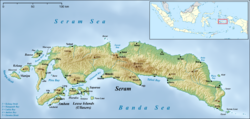
Tehoru is a village on the south coast of the Indonesian island of Seram. The office of the camat of the Kecamatan of Tehoru (a subdivision of the Central Maluku Regency) is located here. Tehoru is at the south end of Teluti Bay on the Banda Sea.[1]
References
- ^ Janse, Mark; Tol, Sijmen (1 January 2003). Language Death and Language Maintenance: Theoretical, Practical and Descriptive Approaches. John Benjamins Publishing. p. 68. ISBN 90-272-4752-8.

