
Thatcher, Colorado
Thatcher, Colorado | |
|---|---|
| Country | |
| State | |
| County | Las Animas County |
| Time zone | UTC-7 (MST) |
| • Summer (DST) | UTC-6 (MDT) |
| ZIP code[1] | 81059 (Model) |
| Area code | 719 |
Thatcher is an unincorporated community located in Las Animas County, Colorado, United States. The U.S. Post Office at Model (ZIP Code 81059) now serves Thatcher postal addresses.[1]
A post office called Thatcher was established in 1883, and remained in operation until 1973.[2] The community was named after M. D. Thatcher, a local cattleman.[3]
Geography
Thatcher is located at 37°32′45″N 104°06′30″W / 37.54583°N 104.10833°W (37.545830,-104.108330).
References
- ^ a b "ZIP Code Lookup" (JavaScript/HTML). United States Postal Service. January 3, 2007. Retrieved January 3, 2007.
- ^ "Post offices". Jim Forte Postal History. Retrieved 11 July 2016.
- ^ Dawson, John Frank. Place names in Colorado: why 700 communities were so named, 150 of Spanish or Indian origin. Denver, CO: The J. Frank Dawson Publishing Co. p. 49.
Municipalities and communities of Las Animas County, Colorado, United States | ||
|---|---|---|
| City | 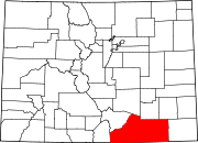 | |
| Towns | ||
| CDPs | ||
| Unincorporated communities | ||
| Ghost towns | ||