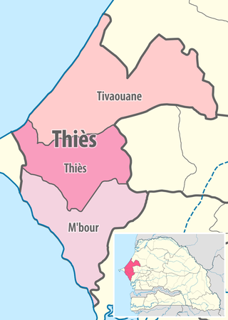
Thiès Department
Appearance
Thiès | |
|---|---|
 Thiès town centre | |
 Location in the Thiès Region | |
| Country | |
| Region | Thiès Region |
| Capital | Thiès |
| Area | |
| • Total | 1,873 km2 (723 sq mi) |
| Population (2023 census) | |
| • Total | 880,266 |
| • Density | 470/km2 (1,200/sq mi) |
| Time zone | UTC+0 (GMT) |
Thiès Department is one of the 45 departments of Senegal, one of the three located in the Thiès Region.
There are 4 urban communes in the department: Kayar, Khombole, Pout and Thiès.
The rural districts (communautés rurales) comprise:
- Arrondissement of Keur Moussa:
- Keur Moussa
- Diender
- Fandène
- Arrondissement of Notto:
- Notto
- Tassette
- Arrondissement of Thiénaba:
- Thiénaba
- Ngoudiane
- Ndiéyène Sirah
- Touba Toul
- Arrondissement of Thiès Nord
- Arrondissement de Thiès Sud

- Thiès town
- Railway station and warehouses
- Place Ibrahima Sarr, Ballabey city
- The building of the Director General of the SNCS
- "Building of the Three Clocks" of the SNCS
- Thiès Fort, now regional museum
- Principal building housing the Government
- Principal building housing the Chamber of Commerce
- Thiès Cathédrale and the Evéché building
- Building housing the Saint Anne's school opposite the Cathedral
- Thiès Post office
- Thiès department
- Mbidièm Fort, Arrondissement de Pout
- Diack Quarries archeological site, Arrondissement de Thiénaba
- Diakité Quarries archeological site
- Pout Post Office
References
[edit]- ^ List of historic sites Archived 2016-03-04 at the Wayback Machine
14°50′03″N 17°06′22″W / 14.83417°N 17.10611°W
