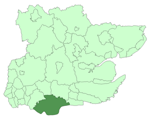
Thurrock Urban District
| Thurrock | |
|---|---|
 Thurrock within Essex in 1961 | |
| Area | |
| • 1936 | 38,324 acres (155 km²) |
| • 1974 | 40,552 acres (164 km²) |
| Population | |
| • 1939 | 63,431 |
| • 1971 | 125,058 |
| History | |
| • Created | 1936 |
| • Abolished | 1974 |
| • Succeeded by | Thurrock |
| Status | Urban district, parish |
| Government | Thurrock Urban District Council |
Thurrock was a local government district and civil parish in south Essex, England from 1936 to 1974.
The parish and urban district was formed from the former area of the following civil parishes which had been abolished in 1936:[1]
- From Grays Thurrock Urban District:
- From Orsett Rural District:
- From Purfleet Urban District:
- From Tilbury Urban District:
The district was enlarged in 1938 by gaining Little Burstead from Billericay Urban District. The district was abolished in 1974. The part within Basildon New Town became part of Basildon District, while the remainder became the present-day Borough of Thurrock. It has since become a unitary district with largely the same boundaries.
References
- ^ Youngs, Frederic (1979). Guide to the Local Administrative Units of England. Vol. I: Southern England. London: Royal Historical Society. ISBN 0-901050-67-9.
