Vari
Vari
Βάρη | |
|---|---|
Settlement | |
| Coordinates: 37°50′N 23°48′E / 37.833°N 23.800°E | |
| Country | Greece |
| Administrative region | Attica |
| Regional unit | East Attica |
| Municipality | Vari-Voula-Vouliagmeni |
| Area | |
| • Municipal unit | 22.633 km2 (8.739 sq mi) |
| Elevation | 25 m (82 ft) |
| Population (2011)[1] | |
| • Municipal unit | 15,855 |
| • Municipal unit density | 700/km2 (1,800/sq mi) |
| Time zone | UTC+2 (EET) |
| • Summer (DST) | UTC+3 (EEST) |
| Postal code | 166 xx |
| Area code(s) | 210 |
| Vehicle registration | Z |
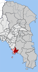
Vari (Greek: Βάρη) is a southern suburb of Athens and former municipality in East Attica, Greece. Since the 2011 local government reform it is part of the municipality Vari-Voula-Vouliagmeni, of which it is a municipal unit.[2] The municipal unit has an area of 22.633 km2.[3]
Geography
It lies at the southwestern end of the Mesogeia plain and the southeast shoulder of the Hymettus mountain, near the Saronic Gulf coast. Greek National Road 91 connects Vari with Athens city centre and Sounio. Vari's beach is located in an area called Varkiza, a fishing village that joined the municipality of Vari, in 1997. This particular beach has won the blue flag many years in the past, including 2009.
After 1 January 2011 Vari joined Voula and Vouliagmeni, according to Kallikratis regulations, in a joined municipality. Grigoris Kasidokostas is the new mayor elected at 14 November 2010 for the new joined municipality. The ancient deme of Anagyrous was situated here.
Historical population
| Year | Population |
|---|---|
| 1981 | 4,211 |
| 1991 | 8,488 |
| 2001 | 10,998 |
| 2011 | 15,855 |
See also
References
- ^ "Απογραφή Πληθυσμού - Κατοικιών 2011. ΜΟΝΙΜΟΣ Πληθυσμός" (in Greek). Hellenic Statistical Authority.
- ^ Kallikratis law Greece Ministry of Interior Template:El icon
- ^ "Population & housing census 2001 (incl. area and average elevation)" (PDF) (in Greek). National Statistical Service of Greece.


